Nitrogen deposition
This section explains the impacts on the environment of nitrogen emissions from traffic flows that would change as a result of operating the Lower Thames Crossing.
As well as explaining our assessments, here we set out our proposals for mitigating and compensating for the predicted impacts. In this instance, mitigation means measures that would reduce the amount of nitrogen emitted, while compensation refers to proposals to offset the emissions by planting new habitats and enhancing existing ones.
As well as addressing congestion at the Dartford Crossing and its approach roads, the Lower Thames Crossing’s objectives include minimising adverse impacts on health and the environment. The new route has been designed to be the greenest road ever built in the UK. It features the country’s longest road tunnel, which would protect the River Thames and nearby wetlands, and seven green bridges to maintain habitat connectivity.
Once open, the new road would form an essential part of the UK’s transport network. Ambitions laid out in the Government’s Transport Decarbonisation Plan will see the sale of new petrol and diesel cars phased out by 2030, with the same expected for heavy goods vehicles from 2035 or 2040, dependent on vehicle class.
The future of road travel is a zero carbon one, powered by zero carbon energy sources, hydrogen and biofuels. As more and more petrol and diesel vehicles are replaced by electric ones, we expect to see the environmental impacts of vehicle emissions go down over time.
Throughout the design and development of the Lower Thames Crossing, we have carried out assessments to understand its impact on the environment. These have included looking at the predicted changes in traffic flows when the new road opens, which has helped us understand the potential impacts of vehicle emissions on the environment.
It is important to assess nitrogen emitted from vehicle exhausts because after it enters the atmosphere, it falls on habitats (a process known as ‘nitrogen deposition’) and can affect the way plants grow. For example, the nitrogen can act as a fertiliser, which can be either good or bad for the plants depending on the extent of deposition. As such, it is important to understand the impact of nitrogen deposition and take steps to reduce the impacts where they are likely to be significant.
Our assessments of vehicle emissions have always been in line with the existing guidance for major road projects.
Since our last consultation, we have revised our assessment methodology in light of the latest scientific opinion and after discussions with Natural England. Our assessment of the impact of vehicle emissions now includes consideration of the impact of ammonia emitted from exhausts, as well as considering the nitrogen oxides (NOx).
Many petrol and diesel vehicles now use catalytic converters to reduce the emissions of some pollutants, such as NOx, but these catalytic converters emit ammonia as a by-product which, along with NOx, can also contribute to nitrogen deposition. Our revised methodology accounts for this and provides a robust assessment of nitrogen deposition and its potential impacts on designated habitats.
Government data shows that nitrogen levels from road transport and other sources have fallen by 79% since 1990. While it is not part of our assessments, as our assessments are precautionary, it is predicted that this downward trend will continue and accelerate as a result of the Government’s ongoing decarbonisation policies. This will result in many plants and habitats near roads improving over time as they are impacted less by nitrogen deposition from vehicles.
However, our latest assessments, which include ammonia emissions, show that changes to vehicle emissions when the Lower Thames Crossing is open may slow down the rate at which nitrogen levels reduce in some locations near the new road. The assessed locations are designated sites (habitats of ecological importance) within 200 metres of the affected roads. As a result of the new road opening, the nitrogen deposition reduction at those sites would not go down as quickly as it would if the Lower Thames Crossing were not built, potentially resulting in the quality of those habitats not recovering as quickly as they would otherwise.
We have already carried out surveys of many of the designated sites to understand how vulnerable the habitats may be to changes in nitrogen deposition. As it is necessary to carry out some surveys at a particular time of year, these are ongoing.
We have undertaken preliminary nitrogen deposition assessments for these areas based on the available traffic modelling.
As the seasonal surveys continue, we will refine our assessments and finalise our proposals for mitigation and compensation, and these will be included in our DCO application. By taking this approach, we can ensure our mitigation and compensation proposals are sufficient to address any nitrogen deposition effects from the implementation of the Lower Thames Crossing.
Our assessment identifies which designated sites are likely to be significantly affected by nitrogen deposition on the basis of the precautionary approach we have taken to the future of vehicle decarbonisation.
The assessment of significance includes considering the amount of nitrogen deposited, the importance of the site, the current condition of the site, the sensitivity of the site’s plants to nitrogen, the duration of the predicted nitrogen impacts, and the proportion of the site affected.
More information about our assessments can be found in the appendix of the guide to local refinement consultation.
The construction of the Lower Thames Crossing would have no significant impact on nitrogen deposition.
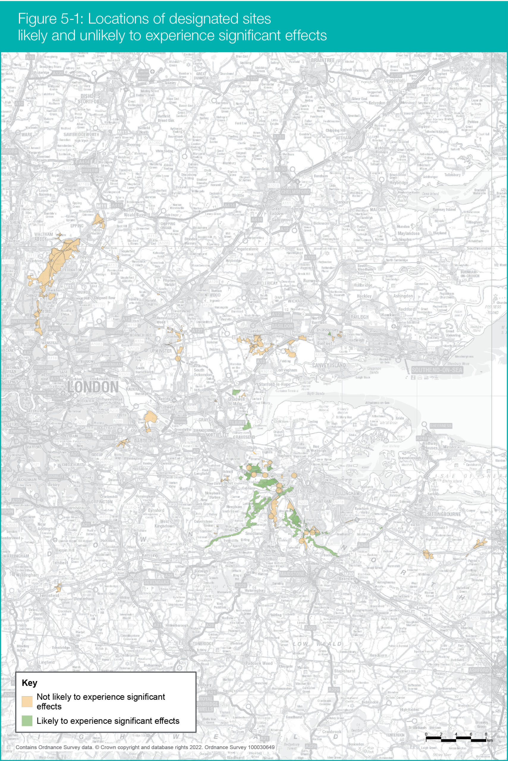
When the new road is open, our precautionary assessments have found that there would be a risk of significant nitrogen deposition effects at approximately 60 of the 136 designated sites being assessed.
None of the 60 are internationally important designated sites, such as the Thames Estuary and Marshes Ramsar and Special Protection Area.
The combined area of the significantly affected designated sites is approximately 250ha. However, there is a possibility that the size of this area may change once additional surveys and further detailed assessments have been carried out.
Figure 5.1 shows the designated sites likely to be affected, based on our current assessments, with most of them south of the River Thames clustered in two locations:
- Along the A2 and M2 between the proposed A2/M2 junction with the Lower Thames Crossing and M2 junction 2
- Around M2 junction 3 and the A229 at Blue Bell Hill
The designated sites north of the River Thames that are most likely to experience significant effects, are more scattered but we have identified two clusters where most of the significant effects are likely to occur.
These are mainly adjacent to the proposed route of the Lower Thames Crossing and consist of a Site of Special Scientific Interest, five ancient woodlands, five local wildlife sites, and a veteran tree. (Veteran trees are those that have a high ecological value, such as providing habitats for insects and fungus.)
The mitigation and compensation measures explained below are designed to reduce or compensate for any significant effects of nitrogen deposition once the new road is open.
Where the risk of significant impacts from nitrogen deposition has been identified, we have investigated mitigation measures that would reduce these effects. Where we have not identified any appropriate mitigation measures to reduce the impacts on nearby habitats, we are proposing compensation measures by creating new habitats and enhancing existing ones.
National Highways’ standards states that the following mitigation measures should be considered where there are predicted to be significant effects on designated sites:
- Reducing vehicle speeds to mitigate air quality effects. This can involve enforcement of an existing 70mph speed limit or reduction of an existing 70mph limit to 60mph.
- Installation of vertical barriers at least 9 metres high.
Our investigations have concluded that there are no sections of motorway where reducing the speed limit is the best solution to managing nitrogen deposition as a result of the new road opening.
Furthermore, installing nine-metre-high barriers between the road and the affected designated sites would have too many negative impacts for this to be appropriate mitigation. The appendix of the Guide to local refinement consultation includes more information about why these measures are deemed unsuitable.
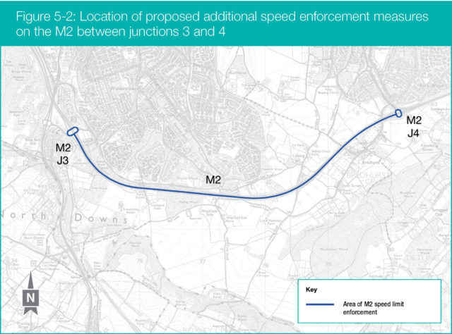
Speed enforcement
Traffic data shows that the speed limit is exceeded by some motorists on some sections of the road network. Driving at faster speeds increases nitrogen emissions, so by enforcing the speed limit on certain sections of road, average vehicle speeds can be brought down, reducing nitrogen deposition on nearby designated sites.
Following our assessment of nitrogen deposition, we have been considering whether installing speed cameras on the M2 between junctions 3 and 4 (see Figure 5.2) once the Lower Thames Crossing is open would be effective in encouraging road users to drive at the legal speed limit, on top of existing enforcement measures. This would provide additional encouragement for motorists to obey speed limits, on top of existing speed enforcement measures. This location has been chosen because our traffic modelling shows that some motorists are likely to exceed the speed limit here when the Lower Thames Crossing is open.
There would be no change to the speed limit, which would help maintain traffic flows and journey times.
We are reviewing whether additional speed enforcement measures at this location would be feasible, taking into account all relevant considerations (e.g. cost, technical feasibility).
Epping Forest Special Area of Conservation
Our assessment has concluded that there would be no significant effects on Epping Forest Special Area of Conservation because nitrogen deposition at this designated site would be very small.
However, we understand that Natural England or other parties may disagree and consider mitigation to be necessary. For this reason, we have investigated mitigation measures that would reduce nitrogen deposition effects on Epping Forest. We have investigated reducing the speed limit from 70mph to 60mph on the M25 westbound between junctions 27 and 26 for four years from the Lower Thames Crossing opening. Our assessment shows that this would have the effect of reducing nitrogen deposition, but we do not consider this measure necessary and are not proposing it.
Proposed compensation land
Where there are no appropriate mitigation measures, then we have identified how best to offset the impacts of nitrogen deposition by creating new compensatory habitats. Creating new habitats would offset the potential significant effects on the designated sites affected by nitrogen deposition. While the primary purpose of the land would be as compensation for nitrogen deposition, the land could also provide additional benefits such as:
- Increasing public access to the countryside. If appropriate we would consider making these sites publicly accessible in a way that complements their primary function as compensatory habitats.
- Improving the appearance of the local landscape by planting
new trees and other plants. - Enhancing biodiversity by increasing the number of linked habitats.
- Planting new habitats that would absorb carbon dioxide from the atmosphere, reducing the carbon impacts of the project.
Our current proposal is that our DCO application should contain the powers to create approximately 250ha of new wildlife-rich habitats. Where possible, these would be linked to existing habitats, improving biodiversity along new ‘green corridors’.
We consider this to be a comprehensive response to the risk of adverse effects on habitats from nitrogen deposition.
Once our full assessments are complete, as a potential additional compensation measure we are looking at whether it would be appropriate to establish a fund to provide financial and technical support for measures that would address any specific effects that are not adequately compensated through new planting. If, following additional assessment and engagement, this is considered appropriate, we would work with stakeholders and landowners to develop these plans. More information about the potential fund can be found in the appendix of the Guide to local refinement consultation.
We have worked with Natural England and the relevant local planning authorities to identify sites that would be suitable for our habitat creation proposals.
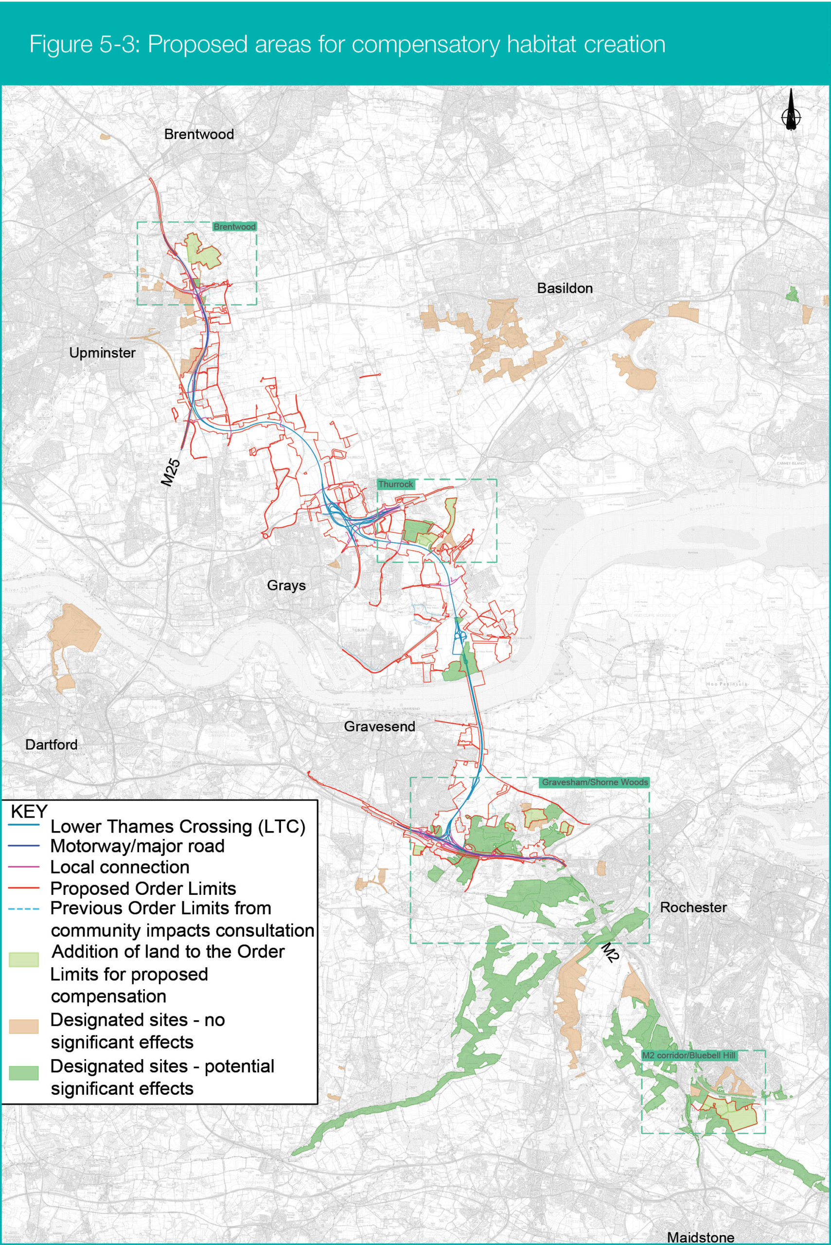
Following this exercise, we have identified 279ha of land that are considered suitable for habitat creation. Following the conclusions of our on-going assessments and this consultation, we intend to refine our proposals to provide approximately 250ha of compensatory habitat. The land is located in four areas:
- M2 corridor and Blue Bell Hill
- Gravesham and Shorne Woods
- Southfields, Thurrock
- Hole Farm, Brentwood
The sites were identified using a detailed selection methodology, which is explained in the appendix. In these locations, significant new areas of wildlife-rich habitats would be created, along with smaller areas that connect habitats that have previously been fragmented. The conclusions of our ongoing work will allow us to refine our proposals further and the final proposals will be included in our DCO application.
Before starting the habitat creation works, we would erect security fencing around the perimeter of the compensation areas. The landscape planting would involve initial ground preparation works, including removal of vegetation where required and preparation of soils using tractors and excavators to get the appropriate soil conditions for the required planting.
Planting would be carried out at the first available planting season. The season of planting would depend on the species selected and when we gain access to the land. In some cases, areas may be allowed to naturally regenerate so that local plants have the chance to establish from seed.
An effort would be made to retain vegetation but where it is beneficial to remove it, clearance would be carried out during winter where possible, to avoid impacts on breeding birds. Where this is not practicable, clearance would be supervised by an Ecological Clerk of Works to ensure no nests are disturbed or destroyed.
The planting of the compensation sites would be developed to have beneficial environmental impacts against other environmental factors, such as landscape. Where it is possible that environmental impacts may occur as a result of the proposed change in land use, these would be minimised through sympathetic design and the application of the control measures set out in the Code of Construction Practice (CoCP) and the Outline Landscape and Ecology Management Plan.
We do not expect there to be any impacts from the habitat creation works on noise levels or air quality. Draft versions of these documents were shared during the community impacts consultation, and these will be updated to reflect the new compensation sites and included in
our DCO application. Our assessments of the impact of planting of the compensation sites will be included in the Environmental Statement, which will also form part of our DCO application.
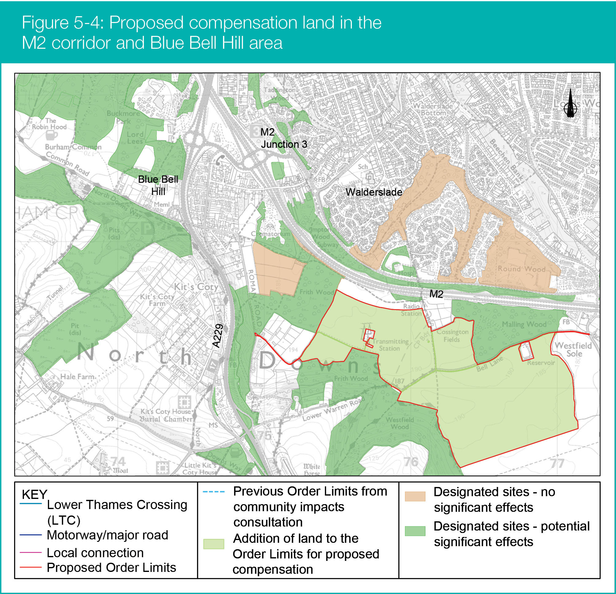
Compensation area: M2 corridor/Blue Bell Hill
This is made up of four parcels of privately owned farmland totalling approximately 104ha and would form one large area for habitat creation. They have been identified due to their size and proximity to several affected designated habitats, as well as other designated sites that are not impacted by the Lower Thames Crossing. The number of these sites bordering this area, such as Frith and Westfield Woods, provides an opportunity to enhance ecological links, including to the North Downs Woodlands Special Area of Conservation. We would create mosaic habitats dominated by woodland but designed to enhance existing habitats.
The compensation area is located within Kent Downs Area of Outstanding Natural Beauty (AONB). This provides an opportunity to compensate for the effects of nitrogen deposition and provide wider ecological and biodiversity benefits for habitats and landscape along the M2/A2 corridor. It would also provide visual screening of an existing overhead powerline in the AONB.
Additionally, historic maps show that this currently farmed compensation area was wooded in the nineteenth century. This recent past means that, it would be more appropriate for woodland creation for both ecological and landscape reasons than other areas that have been cleared of woodland for longer.
Further work will also be carried out to identify potential opportunities for the compensation area to connect to the North Downs Way.
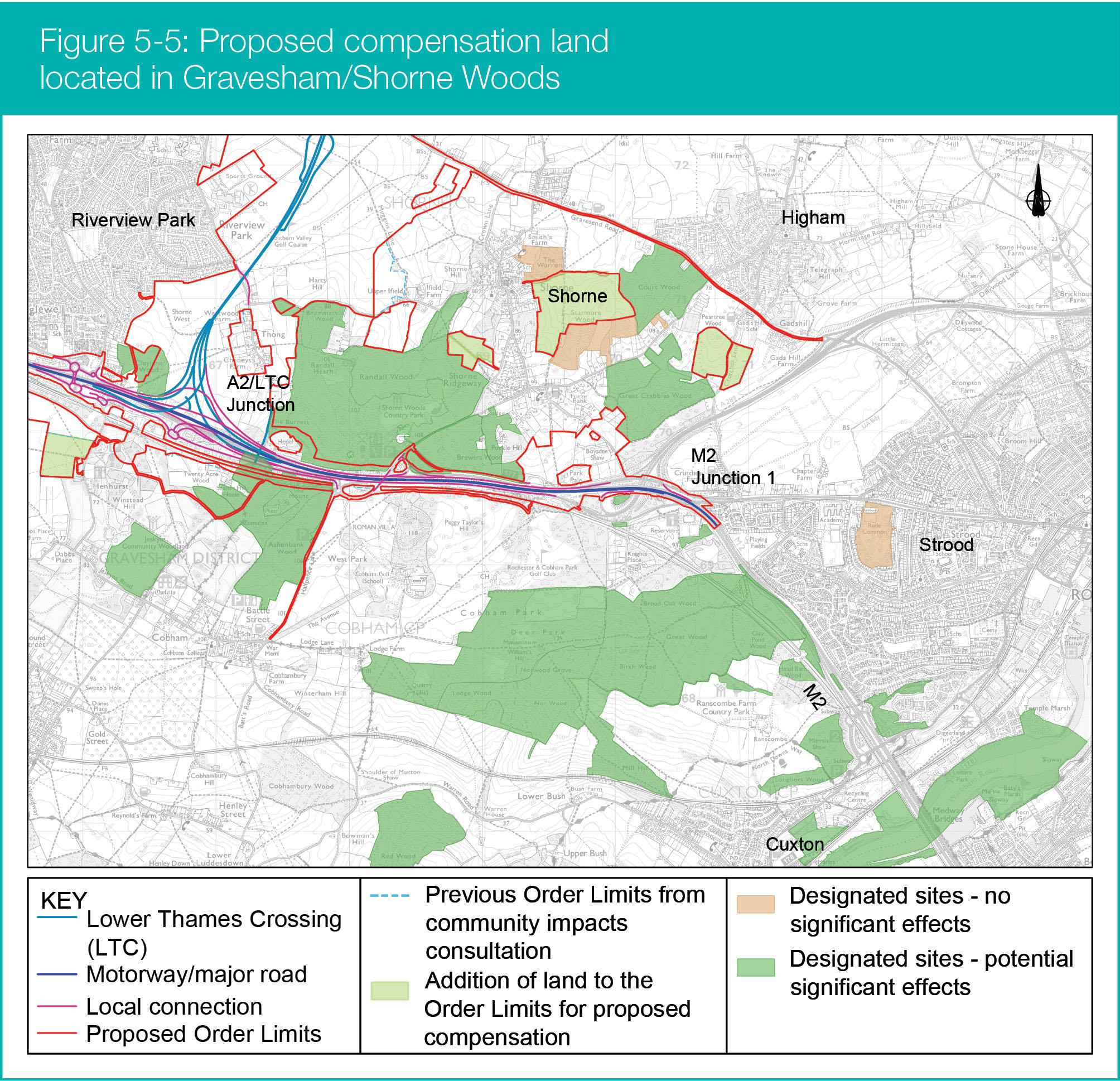
Compensation area: Gravesham/Shorne Woods
This compensatory area is made up of four parcels of privately owned land, as show in Figure 5-5. Together, they total approximately 55ha. They have been identified due to their location in relation to affected habitats and their suitability to improve connectivity between existing habitats.
Creating new habitats here would reconnect existing woodland across the Shorne Woods area that has been subject to severance and isolation in the past. The parcels are also next to, or form part of, a wider approach to mitigation and compensation, with other areas to be planted as mitigation, for instance, for loss of ancient woodland. The combination of these parcels of land and other mitigation would comprehensively enhance habitats in this area through natural regeneration and targeted planting.
The northern proposals, located to the north of the A2, include three parcels of agricultural land totalling approximately 46ha. These are next to Shorne and Ashenbank Woods SSSI, Great Crabbles Wood SSSI and ancient woodlands. The parcels of land would not create a single large area of new habitat but would link existing woodlands and habitats. They would be carefully designed, planted and managed to support and enhance the specific habitats within the adjacent woodlands.
The western site, which is currently farmed and located south of the A2, is close to Ashenbank Woods and totals approximately 9ha. This area has been identified due to its proximity to an impacted site and it is also next to woodland planting mitigation for the loss of ancient woodland. It would therefore provide ecological benefits, including improved links for existing habitats and the creation of a larger ecological area through mitigation and compensation. Its selection and planting would establish a mosaic of woodland in other habitats that enhances existing habitats and integrates with the landscape.
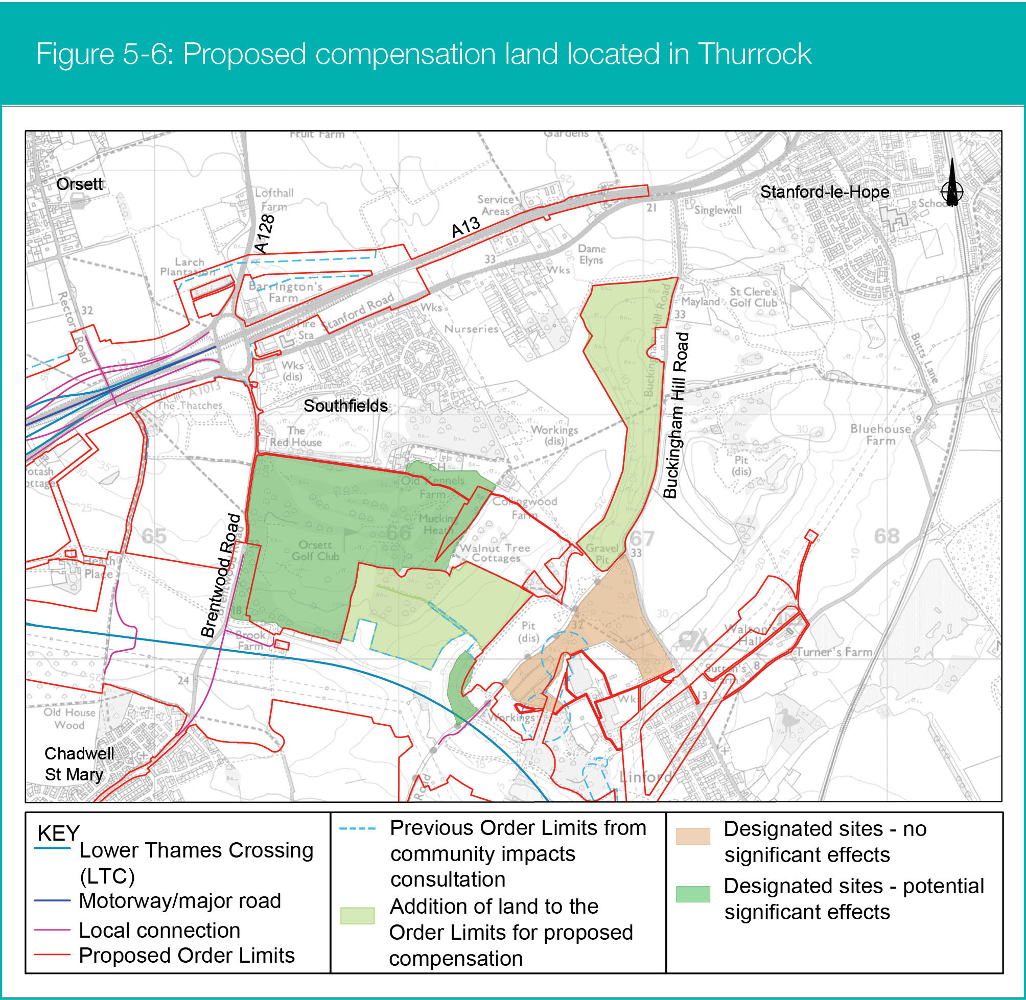
Compensation area: Thurrock
Two parcels of land totalling approximately 45ha have been identified in Thurrock (see Figure 5-6) for compensatory planting. The eastern area of land shown on the map is publicly owned, whereas the area to the west is private farmland. Both are located to the south of the A13 in Southfields and are close to designated sites and existing woodland that are impacted by nitrogen deposition.
Creating new wildlife-rich habitats would increase connectivity between existing habitats, which would be beneficial both ecologically and from a landscape perspective. The privately owned site was identified as it is a farmed field next to an impacted habitat.
We would use a combination of natural regeneration (where woodlands develop naturally from seeds that have fallen on the ground) and planting to create wooded areas next to existing ones that merge into more open habitats. To be sensitive to the valley landscape, these could include parkland featuring scattered trees in grasslands.
The eastern area is a brownfield site, formerly used for landfill, owned by Thurrock Council. It mostly consists of grassland with some sections of scrub. It was identified because:
- It would reduce the need to use further areas of farmland
- It would reduce the impact on other landowners and productive land
- It is in a good position for connecting habitats
We would encourage the development of wildlife-rich habitats on this site by promoting natural regeneration, with targeted planting where necessary.
Our proposals would need to carefully take into consideration any constraints from the site’s former use as a landfill. Prior to any soil disturbance or vegetation removal, to prevent the potential disturbance of residual contamination appropriate risk assessments would be carried out. The Contractor undertaking the works would provide method statements for acceptance by National Highways and, if required, consultation with the Environment Agency before starting works.
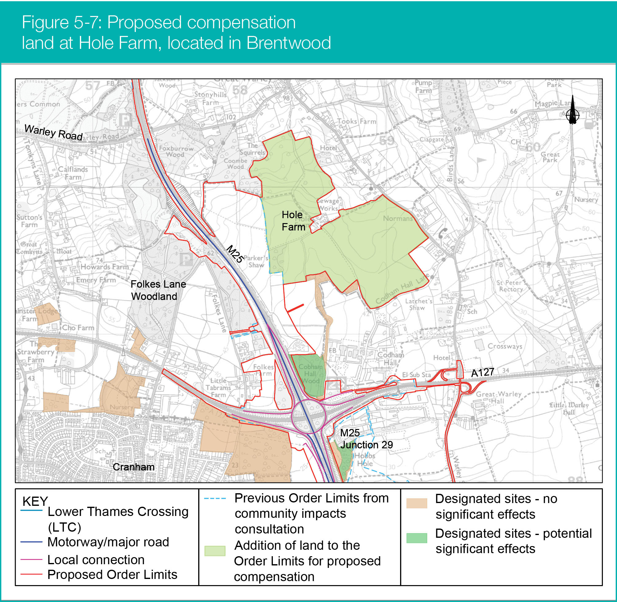
Compensation area: Hole Farm, Brentwood
Most of the Hole Farm site was purchased by National Highways in 2021 to deliver benefits for communities and the environment. Working in partnership with Forestry England and the wider Thames Chase Community Forest partners, the site was identified as providing an opportunity to create a new community woodland that would become part of the Thames Chase Community Forest network.
This would build on the small proportion of the site adjacent to the M25 that was already needed by the Lower Thames Crossing to provide public open space replacement for works at Folkes Lane Woodland.
Following our assessments, we identified Hole Farm, which is currently used for agricultural purposes, as a location for compensatory habitat creation because it is close to Codham Hall Woods and other designated sites. It would also link with the existing woodlands that form part of the habitat network in this area. There is an existing farmhouse and paddock within Hole Farm that will be retained and these are not included in our proposals for Hole Farm.
We are considering using up to 75ha of the Hole Farm site as compensatory planting to offset against the risk from impacts of nitrogen deposition caused as a result of traffic using the Lower Thames Crossing. Within this 75ha, we would convert the existing farmland to a woodland-dominated mosaic of wildlife-rich habitats through a combination of natural regeneration of habitats and planting.
This compensatory planting would form part of, and integrate with, the masterplan for the entire site that is being developed in partnership with Forestry England and the wider Thames Chase Community Forest partners. The masterplan will also include proposals for the facilities associated with a community woodland such as a tree nursery and a visitor centre.
A period of community engagement to inform the development of the masterplan for the site is on-going and a public consultation on the proposals will be undertaken ahead of an application being submitted to Brentwood Borough Council to change the use of the site and create the required visitor facilities.
It is proposed that these elements would be consented separately from the Lower Thames Crossing DCO application. The final amount of land within Hole Farm allocated to nitrogen deposition compensatory planting will align with the aspirations, and masterplan, for the overall site.
Ongoing work
This website records the work we are doing to address the potential risks to nearby habitats from nitrogen deposition from traffic using the Lower Thames Crossing.
It explains our work in progress and our current thinking about the right approach to mitigation and compensation. We have more assessments to carry out but the feedback from this consultation will inform the approach that we submit and secure as part of our DCO application.
Our work includes:
- Refinement of assessments based on finalised traffic and air
quality modelling. - A decision on whether to implement additional speed enforcement on the M2 between junctions 3 and 4, followed by further development of these proposals, which would be informed by the responses to this consultation and site surveys.
- Further development and refinement of the proposals for compensation measures, informed by the responses to this consultation, including:
- desk-based assessments and site visits to collect further information on constraints affecting potential compensation sites (such as utilities not previously identified) and opportunities (including connections to existing woodland or habitats of ecological value)
- refining the proposed compensation areas
- defining and agreeing overarching objectives and environmental design principles for each compensation area
- outline design of the compensation areas, covering species mix, layout, maintenance and management requirement
- Ongoing engagement with stakeholders, including landowners, throughout the development of our mitigation and compensation proposals.
- Development of the habitat management fund if it is considered necessary to complement the new habitat creation. This includes further measures to address specific impacts that may not be fully compensated through the new habitat creation.
Design and assessment
Our assessments of the impact of nitrogen deposition on ecological habitats and our proposals for mitigating and compensating for it will be included in the Environmental Statement and the Habitats Regulations Assessment that will form part of our DCO application.
The Order Limits presented in this consultation include the potential locations for compensation planting outlined above.
The location of the compensation areas will be shown in our DCO application and would, with the exception of Hole Farm, be the subject of compulsory acquisition powers, as a fallback measure should we be unable to reach an agreement with landowners. The location of the compensation areas will be presented in the Environmental Masterplan, which will form part of the Environmental Statement and the DCO application.
The outline management and maintenance requirements will be presented within the Outline Landscape and Ecological Management Plan (OLEMP), which will detail the proposed management of the landscape and ecological elements of the Lower Thames Crossing.
A draft copy of the OLEMP was consulted on during our community impacts consultation. It will be further developed with additional detail for our DCO application. Furthermore, all the new compensation areas would be subject to the requirements and controls set out in the DCO and associated documents.
The compensation proposals that are currently being assessed and refined will be included within the EIA and reported within the Environmental Statement. This will cover environmental assessments of any potential effects on cultural heritage, landscape and visual, terrestrial biodiversity, soils and other relevant topics if required following desk-based assessments and site visits. If the ongoing work confirms that the mitigation measures are to be progressed, these will also be included within the Environmental Statement.