You said, we did
We have used feedback from our community impacts consultation in 2021, along with ongoing engagement with stakeholders and landowners, to refine the project.
We asked
During the consultation, we asked questions to understand the level of support for the different elements of the project. Consultees could also expand on their answers. The response form was split into four sections:
- the project’s impacts and mitigation
- changes since the design refinement consultation
- Order Limits
- the ‘You said, we did’ document presented at the community impacts consultation
You said
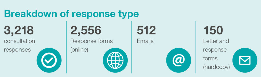
3,218 responses to the community impacts consultation were received.
Overall, the feedback we received supported the proposals presented across all four sections. Responses to some of the questions asked at the community impacts consultation are outlined below.
The project’s impacts and mitigation
- 1,564 (59%) respondents supported or strongly supported our plan to build the Lower Thames Crossing; 973 (36%) opposed or strongly opposed.
- 1,231 (47%) respondents supported or strongly supported our plan to operate the Lower Thames Crossing; 847 (33%) opposed or strongly opposed.
Changes since the design refinement consultation
- 1,367 (54%) respondents supported or strongly supported the proposed changes south of the river; 721 (25%) opposed or strongly opposed.
- 1,300 (51%) respondents supported or strongly supported the proposed changes north of the river; 824 (31%) opposed or strongly opposed.
Order Limits
- 1,335 (52%) respondents supported or strongly supported the proposed area of land that would be needed to build the Lower Thames Crossing; 783 (31%) opposed or strongly opposed.
- 1,432 (57%) respondents supported or strongly supported the proposals for the inclusion of a new open space site, Tilbury Fields; 528 (21%) opposed or strongly opposed.
- 1,051 (42%) respondents had no preference about the two options presented for the height of the landform at Tilbury Fields; 387 (16%) were in favour of the higher landform, 226 (9%) were in favour of the lower landform and 501 (20%) were in favour of neither.
You said, we did
- 1,244 (49%) respondents supported or strongly supported how issues and suggestions about the Lower Thames Crossing have been addressed following earlier rounds of public consultation; 739 (29%) opposed or strongly opposed.
These statistics are taken from the ‘Response to community impacts consultation’ document. More information about this is included below.
We did
We presented some changes to the project in our community impacts consultation, including refinements to utility diversions, changes to special category land and amendments to the Order Limits. We listened to feedback and considered this carefully when developing our proposals. We believe the changes presented were an improvement to the project and these were generally supported by respondents. We have, therefore, decided to incorporate them within our proposals.
Our Consultation Report, which will be part of our DCO application, will set out how we considered the feedback received in relation to these changes. We are now proposing further refinements to the project and are seeking your views on the Proposed changes since the community impacts consultation.
Below we explain the changes to the project that we are proposing to make and that have been influenced by feedback received at the community impacts consultation. We are seeking your feedback on these changes as part of this consultation.
If you would like to find out more about the feedback received from the community impacts consultation, we have published a document called ‘Response to community impacts consultation’. It includes graphs showing the results for all the questions that we asked. We’ve also summarised the most common feedback received and provided a response for the issues that were raised.
The document also explains some of the minor refinements we have made to the project in response to ongoing engagement with stakeholders and landowners. It can be found on our Public presentations and documents page.
We are currently drafting detailed responses to all the issues raised at our community impacts consultation. This will form a chapter of the Consultation Report within our DCO application, which we plan to submit later this year.
- Draft Development Consent Order schedule 2 & explanatory note
- Outline Site Waste Management Plan
- Outline Traffic Management Plan for Construction
- Outline Materials Handling Plan
- Code of Construction Practice (including the Register of Environmental Actions and Commitments)
- Design Principles
- Wider Network Impacts Management and Monitoring Plan
- Outline Landscape and Ecology Management Plan
- Framework Construction Travel Plan
Changes we are proposing
Below we describe the changes we are proposing that have been influenced as a direct result of feedback received from the community impacts consultation.
For more detail on these, and to read about other changes we are consulting on as part of this local refinement consultation, the Proposed changes since the community impacts consultation page includes maps, visuals and a description of the impacts.
NOTE: We refer to the Lower Thames Crossing as ‘LTC’.
Change summaries
Refinements to woodland planting around Shorne Ifield Road – We are proposing to relocate some of the area of compensatory tree planting that was previously proposed north of Shorne Ifield Road, to fields south of Shorne Ifield Road. This is to avoid a significant impact on the archaeology linked to a newly discovered medieval settlement north of the road. This change responds to consultation feedback from nearby residents, who requested that the area for tree planting be moved to maintain their existing views.
Map: A2/M2 corridor
Ref: 1
Redesignation of Hever Court pedestrian-cycle track north of A2/LTC junction to a bridleway – Following consultation feedback from the British Horse Society about improving connections for horse riders in the area, we are proposing to redesignate the Hever Court pedestrian-cycle track, north of the A2/LTC junction, to a bridleway. This would improve local connections for horse riders from the existing bridleway along NCR 177 to footpath NG17 (also upgraded to a bridleway). In addition, this would provide better links with existing bridleways and newly created routes to Chalk Park.
Map: South of Gravesend
Ref: 2
Redesignation of footpath NS169 as pedestrian-cycle track at Michael Gardens – We received feedback from the local community and the British Horse Society about the potential presence of horses near the play area in Michael Gardens and the lack of stables in this location, meaning it is less likely to be used by horse riders. As a result, we are proposing to redesignate the existing footpath NS169 as a pedestrian-cycle track, rather than a bridleway (as proposed at the community impacts consultation). The redesignation of Hever Court Road (described above) would provide better access for horse riders to the proposed new routes and existing ones.
Map: South of Gravesend
Ref: 3
A2 Roman Road increased working area for electricity works – We are proposing an extension of the Order Limits to include the road and footpath of a section of Roman Road and Pepper Hill. This is to provide enough room for the electricity cables (required to provide a permanent power supply for the southern tunnel entrance building and the tunnel) and would avoid the potential closure of NCR 177. It would also mean that existing vegetation in this area can be retained. This proposal has been developed following further investigations by UK Power Networks, which had some concerns about delivering the works along the previous footpath alignment. In addition, this proposal addresses comments raised at the consultation about retaining vegetation that screens the A2 corridor from the cycle route and limits any new visual impacts.
Map: South of Gravesend
Ref: 4
Extension of open space provision (east of Chalk Park) – We listened to concerns at the community impacts consultation that existing public open space would be negatively impacted by the project. After further engagement with the landowner and additional design development, we propose to permanently acquire the remaining 8ha area of Southern Valley Golf Club. By extending our open space proposals in this location, we would be able to provide a larger area of landscaped amenity space for the local community.
Map: A2/M2 corridor
Ref: 5
Redesignation of footpath NG8, south of the A226 Gravesend Road – Further to discussions with the British Horse Society and its request for an equestrian route parallel to the A226 Gravesend Road, we are proposing to redesignate the northern section of footpath NG8 so it could be used by walkers, cyclists and horse riders. This addresses feedback from the British Horse Society that the previous proposal, which used the footpath and verge along the A226 Gravesend Road, was unsuitable due to the narrow verges.
Map: South of the River Thames/southern tunnel entrance
Ref: 6
Redesign of Tilbury Fields – In response to consultation feedback from the Port of Tilbury and Thurrock Council, as well as ongoing stakeholder engagement, we are proposing changes to the design of Tilbury Fields. Our changes would ensure Thames Freeport proposals can be brought forward alongside the LTC. The changes include redesigning the environmental mitigation and open space provision, as well as changes to construction access in the area.
Map: Tilbury area
Ref: 7
Removal of proposed Dock Road water connection – We are proposing a reduction in the area of land required in the Dock Road, Hume Avenue and Port of Tilbury area. Following discussions with Essex and Suffolk Water, we no longer require the proposed pipeline along Dock Road. This change addresses concerns raised by residents at the community impacts consultation as it means that the connection would no longer take place on a residential road (Dock Road). It also means the associated traffic management measures are needed for two months instead of nine.
Map: Tilbury area
Ref: 10
Coopers Shaw Road water connection refinement – At our previous consultations, potential routes for a new temporary water pipeline were presented along Coopers Shaw Road, Rectory Road and Dock Road. Following ongoing discussions with Essex and Suffolk Water and having considered the potential noise impacts for residents on Rectory Road, we have decided that the proposed new water pipeline should be placed around Coopers Shaw Road. This would reduce construction work and the associated traffic management, responding to concerns from residents about the impacts of construction. This change means that the proposals along Dock Road, Hume Avenue, the A1089 to Fort Road access road, Rectory Road, Church Lane and part of Station Road are no longer required and the land associated with these proposals can be removed from the Order Limits.
Map: Tilbury area
Ref: 11
New footpaths to link the heritage assets of Coalhouse Fort, Coalhouse Battery and Bowaters Battery to East Tilbury – Following feedback from the consultation about linking Tilbury Fields to Coalhouse Fort and providing access for all users, we are proposing to include new Public Rights of Way and permissive path links to the heritage sites of Coalhouse Fort, Coalhouse Battery and Bowaters Battery, and to East Tilbury. These new connections would create a variety of alternative routes that walkers, cyclists and horse riders in the local area could use. This change also addresses feedback from Thurrock Council about active travel routes around the Coalhouse Fort area.
Map: Tilbury area
Ref: 12
New Orsett Cock/A1089 junction link road – To address concerns about traffic re-routing on to the local road network in this area, we are proposing to change how traffic on the A13 corridor would access the A1089. We propose a new link road from the Orsett Cock junction to the A1089 southbound. This change also addresses feedback from Thurrock Council, the Port of Tilbury and DP World about the lack of connectivity between the LTC and the A1089, and the resulting impacts on other local roads.
Map: A13/A1089 junction
Ref: 16
Refinements to the route of a gas pipeline diversion around Orsett –We are proposing to change the route of a gas pipeline diversion to avoid a scheduled monument and veteran tree west of Orsett. This results in minor changes to the Order Limits along the length of the diversion route, which would reduce the area needed for works overall by approximately 2ha. This change responds to feedback from Cadent Gas and addresses concerns raised by the public about impacts to veteran trees.
Map: A13/A1089 junction
Ref: 17
Refinements to electricity works west of Clay Tye Road – Following site investigations, engagement with UK Power Networks and feedback from landowners, we are proposing to use more of the existing infrastructure to deliver changes to the electricity network in this location. Instead of laying cables underground, the powerlines would remain overhead but would be diverted north on to two taller pylons to cross the M25. This removes the requirement for an electricity substation on Clay Tye Road. This change would also reduce the time required for construction of this diversion and also addresses feedback from UK Power Networks and the landowner about protecting farmland.
Map: M25 junction 29
Ref: 23
Refinements to the electricity diversion north of St. Marys Lane – To address concerns about impacts to local communities during construction, we are proposing to move the working area for construction to the east of properties in Tyas Stud Farm. This would enable access for construction, operation and maintenance from Warley Street from the east to the works area, which requires an extension to the Order Limits. The number of properties impacted by construction would be reduced and the change would also remove 2.5ha of land from the Order Limits. This change addresses feedback from UK Power Networks about extending the works area to provide enough space to deliver the diversion.
Map: M25 junction 29
Ref: 24
New walking, cycling and horse riding bridge over the A127, west of M25 junction 29 – Following feedback from the London Borough of Havering and local cyclists’ groups, we are proposing a new bridge for walkers, cyclists and horse riders across the A127 west of M25 junction 29, linking Moor Lane in the south to Folkes Lane in the north. This change addresses consultation feedback about connectivity between the north and south footways and cycleways alongside the A127, to both east and west sides of the M25.
Map: M25 junction 29
Ref: 25
Upgrade of walking, cycling and horse riding bridge over the A127, east of M25 junction 29 – Following consultation feedback from the British Horse Society and Essex County Council, and safety concerns about horses sharing routes with motor traffic, we are proposing an update to the planned A127 bridge so it can accommodate horse riders and to include a link to bridleway BR183. This means horse riders would no longer be dependent on the existing vehicle bridge across the A127, which is shared with motor traffic including HGVs.
Map: M25 junction 29
Ref: 26