Proposed changes since the community impacts consultation
The proposed changes described in this section are a result of feedback received from the community impacts consultation, ongoing engagement with landowners and stakeholders, design work and a greater understanding of technical constraints.
To describe the changes in in more detail, we have divided the route into two sections:
- South of the river in Kent: A2/M2 corridor, south of Gravesend (A2/Cyclopark), south of the River Thames/southern tunnel entrance.
- North of the river in Havering, Thurrock and Essex: Tilbury area, A13/A1089 junction, Mardyke Valley/North Road, M25/junction 29.
We have also detailed changes to:
- Improvements for walkers, cyclists and horse riders
- Special category land
- Private recreational facilities
- Order Limits
- Utilities
- Sustainable construction
We want your your feedback on these changes, as well as the nitrogen deposition impacts, as part of this consultation.
NOTE: We explain the numbered changes on the maps in the south of the river, north of the river and improvements for walkers, cyclists and horse riders sections. The images used are illustrative for this consultation and may change as a result of our ongoing assessments and the feedback we receive. The pictures of our local refinement consultation proposals illustrate how locations might look 15 years after the opening of the Lower Thames Crossing.
Landowner engagement and minor refinements document
We have published a document called ‘Landowner engagement and minor refinements’, which explains the other changes we are taking forward as part of the project following engagement with affected landowners and others with an interest in land. It includes route section maps that detail the further minor refinements we are making to the project. This can be found on the public presentations and documents page.
The Lower Thames Crossing route
The map below explains how we have divided up the route.
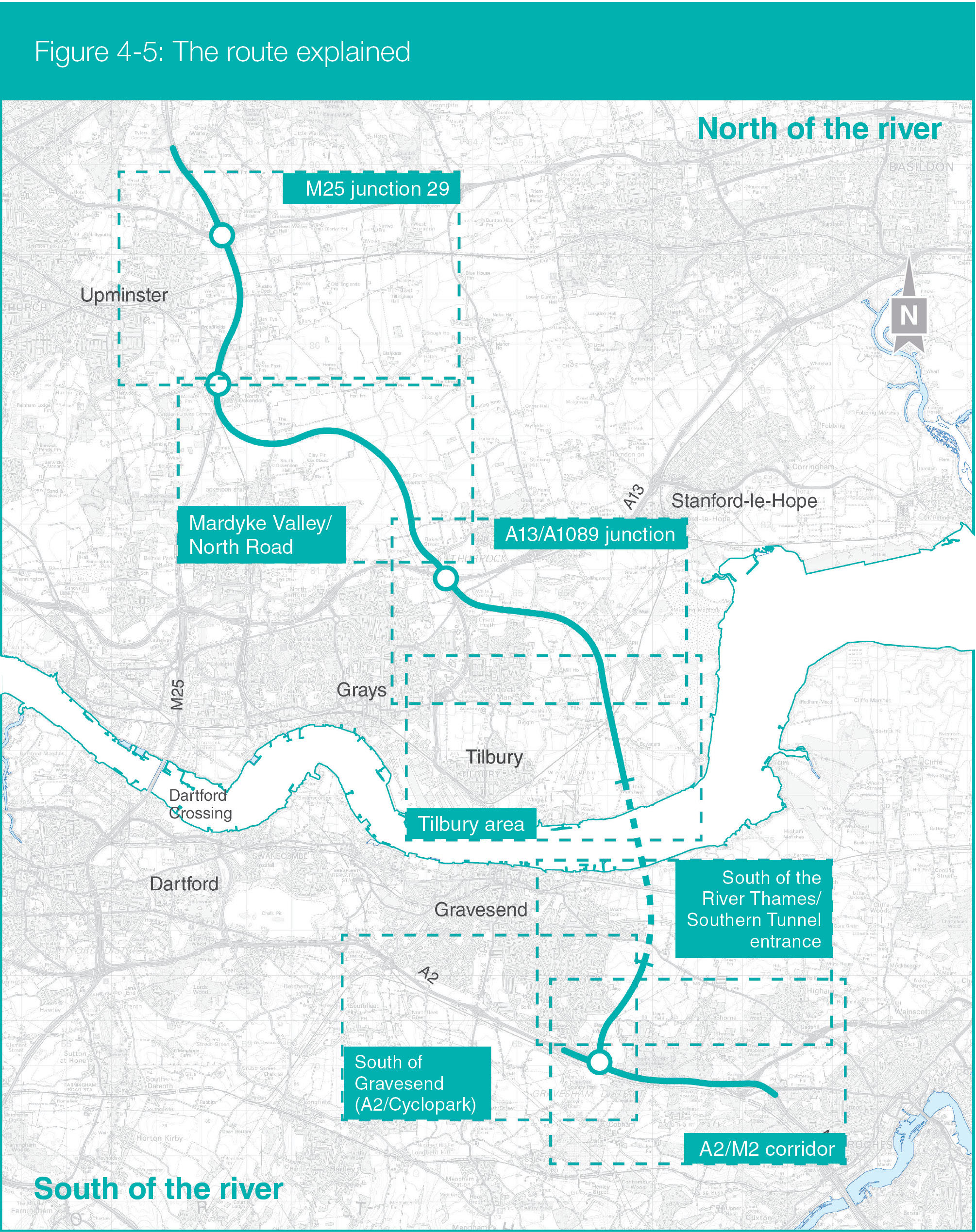
South of the river in Kent: A2/M2 corridor, south of Gravesend (A2/Cyclopark), south of the River Thames/southern tunnel entrance.
North of the river in Havering, Thurrock and Essex: Tilbury area, A13/A1089 junction, Mardyke Valley/North Road, M25/junction 29.
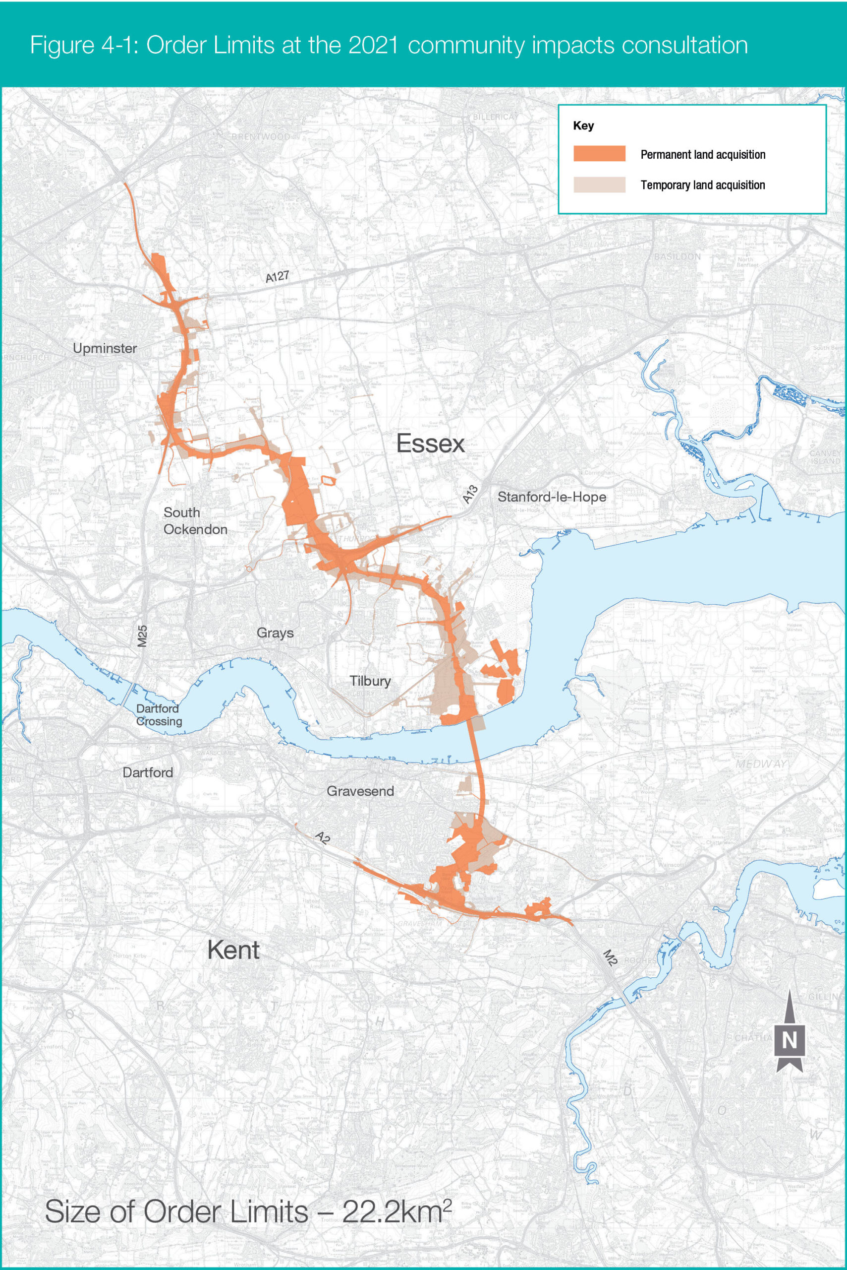
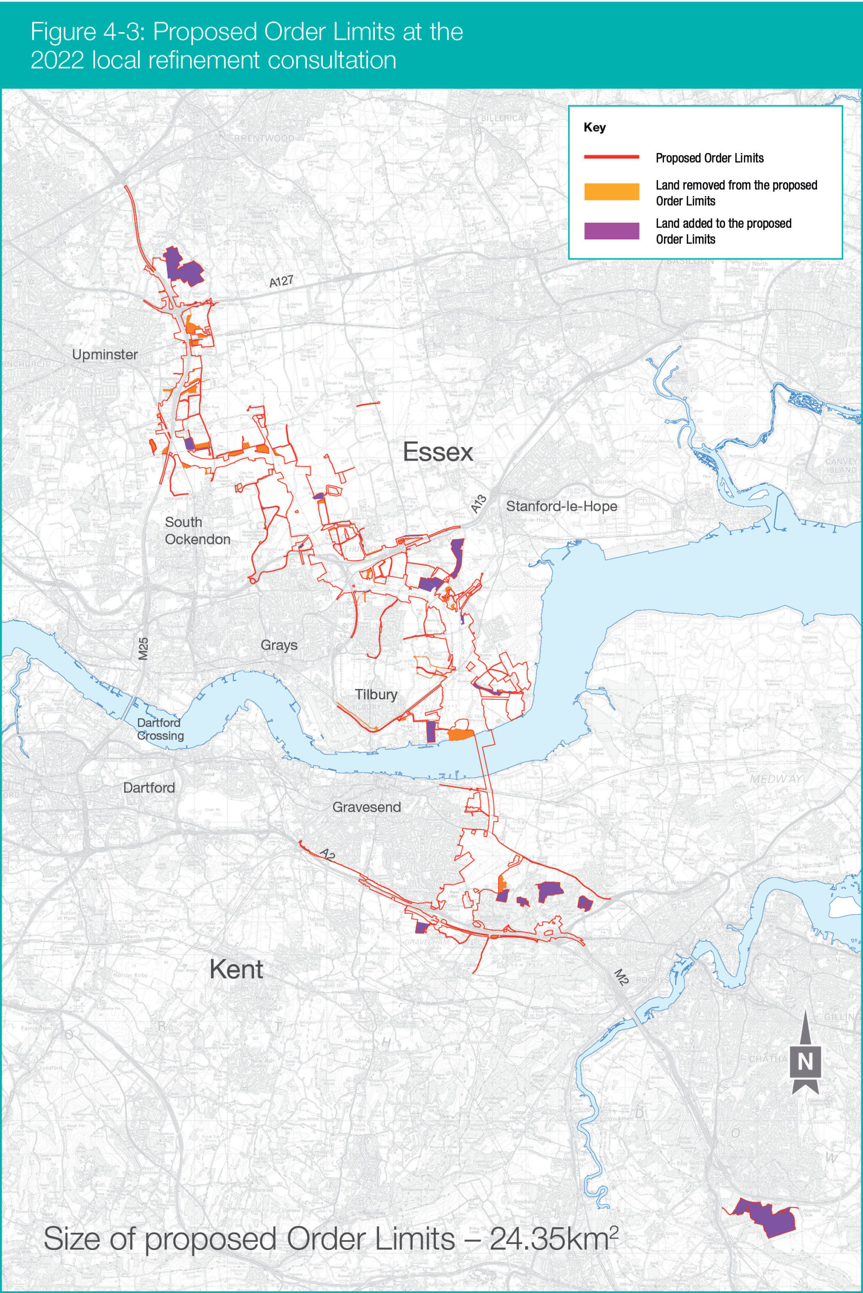
The Order Limits are the outermost edges of the Lower Thames Crossing project. They are indicated on the route section maps by a red line. This shows the land that may be acquired or used to build and operate the project and the areas to which the DCO would apply.
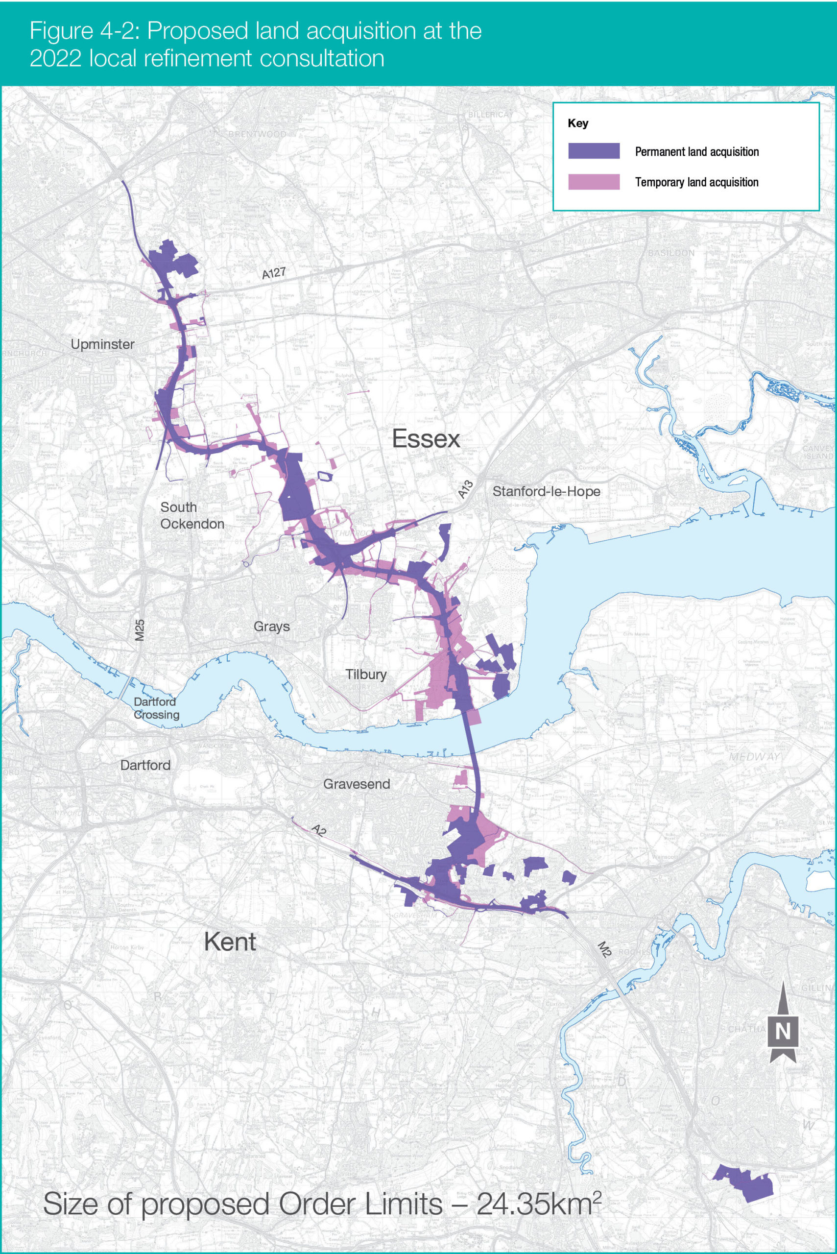
The Order Limits proposed at the previous consultation are indicated by a blue dashed line. Additional land now required for the project is shown by purple shading. Land removed from the Order Limits is indicated by light orange shading.
Following engagement with stakeholders, refinements to the utilities design and feedback from the community impacts consultation, we have further refined our Order Limits in certain areas. Land added to the Order Limits includes four habitat compensation areas in Brentwood, Thurrock, Shorne Woods (in Gravesham) and along the M2 corridor/Blue Bell Hill (in the boroughs of Tonbridge & Malling and Maidstone).
This additional land is indicated by light green shading. These sites are proposed to compensate for the potential effects from nitrogen caused by the forecast changes in traffic as a result of the Lower Thames Crossing.
Dedicated figures show the extents of the compensation areas along with more information on the reasons why these additional sites have been identified and included within the Order Limits on the Nitrogen deposition page. The figures giving an overview of changes in each section of the Lower Thames Crossing route do not show all of the compensation areas such as the land near Blue Bell Hill, given its location away from the Lower Thames Crossing route.
The land within the revised Order Limits has increased from 22.2km2 to 24.35km2. There is no change to the number of properties in the Order Limits as detailed in the community impacts consultation.
Since the previous consultation, we have continued to work with utility companies and affected parties to develop the proposals for utility works. This has resulted in some refinements to the Order Limits and the proposed land use to deliver these works. These changes seek to ensure the road and the utility networks can be constructed and operated in a way that is sensitive to local communities and the environment.
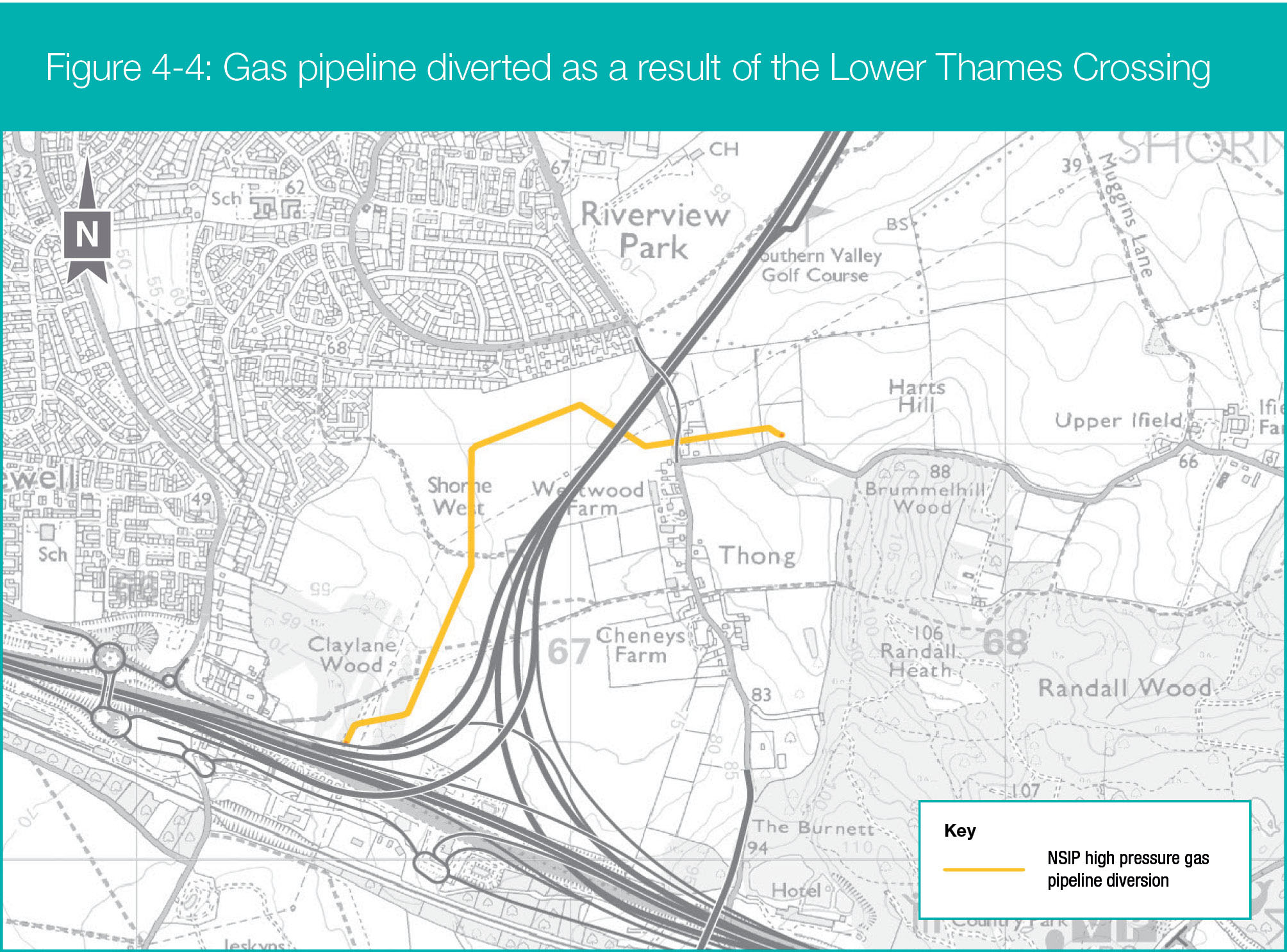
In our community impacts consultation we identified a number of utility diversions that would meet the relevant criteria for them to be defined as Nationally Significant Infrastructure Projects (NSIPs) in their own right. As we have developed our assessments, we have identified that a gas pipeline diversion between the A2 and Thong Lane, presented in our previous consultations and shown in Figure 4-4, would also qualify as an NSIP.
The proposals for diverting this gas main have not changed. Details of other utilities works that meet the relevant NSIP thresholds were presented as part of our community impacts consultation. We continue to keep the legal assessment of whether the proposed works are NSIPs under review and our DCO application will set out all of the utilities-related NSIPs for which development consent is being sought.
In our community impacts consultation, we reported that the construction of the project would result in more than 1,200,000 cubic metres of surplus excavated material to the north of the river. This would need to be transported via the road network for disposal and managed outside of the Order Limits.
Since then, we have continued to refine our design and proposals for landscape mitigation to reduce the amount of material that would need to be transported. This includes:
- Updated landscaping design at various locations around the A13/A1089 junction and at the M25/Lower Thames Crossing junction in North Ockendon (within the previous consultation Order Limits) to provide noise mitigation bunds, enhance biodiversity and create other environmental benefits. This would involve the reuse of clean excavated material for construction activities.
- Raising the road level in cuttings where this can be achieved without increasing other impacts (for example visual and noise). This means that less material would need to be excavated and disposed of. Raising the road level in this way is proposed at a section of the route along Ockendon Link at North Road crossing (‘The Wilderness’) and at the M25/Lower Thames Crossing junction (North Ockendon).
Including these proposals within the DCO application would result in a reduction of approximately 700,000 cubic metres of excavated material required to be disposed off-site. As a result, this would reduce the need to use local waste management infrastructure and reduce the truck movements on the road network during the construction period (compared with the proposals at the community impacts consultation).