North of the river in Havering, Thurrock and Essex
The proposed changes north of the river in Havering, Thurrock and Essex are as a result of feedback received from the community impacts consultation, ongoing engagement with landowners and stakeholders, design work and a greater understanding of technical constraints.
To the north of the river, we are consulting on:
- changes to the design of Tilbury Fields (a new public park on the north bank of the Thames) to make space for the planned Thames Freeport
- replacing an existing slip road with a new link from the Orsett Cock roundabout to the A1089 southbound to reduce traffic impacts on some local roads
- a new footbridge over the A127 and further improvements for walkers, cyclists and horse riders
- improvements to our landscaping proposals
- refinements to our plans for the changes needed to utilities in the local area
- additional environmental compensation and mitigation
Watch our brief video introducing the changes in Thurrock, Havering and Essex.
You can also watch a longer, more detailed video in our video library here.
Changes to Tilbury Fields and our permanent access to the surrounding areas
The Thames Estuary is the UK’s number one growth opportunity. Vital to this are Thames Freeport and the Lower Thames Crossing. Thames Freeport has the potential to deliver 25,000 new jobs and will be much better connected to the rest of the country if the Lower Thames Crossing is constructed. Together, they represent a huge opportunity for economic regeneration. Thames Freeport, connected via the Lower Thames Crossing, can maximise the beneficial use of land to the north of the Thames, which has been under-used for decades.
To support this wider regeneration of the area, we have amended our proposals for Tilbury Fields public park and environmental mitigation. These are explained below.
The revised proposals for Tilbury Fields include more recreational routes and links to footpaths than we previously proposed, an increase in the amount of mosaic habitat proposed and improved connectivity to existing habitats. In addition, we are proposing seven landforms that will act as a visual separation from the more industrial East Tilbury and the development expected at the Freeport.
We are also proposing changes to our permanent operational access arrangements to allow maintenance and emergency vehicles to access the new road in this location. In addition, we are working to align our construction activities to better support the development of the Freeport.
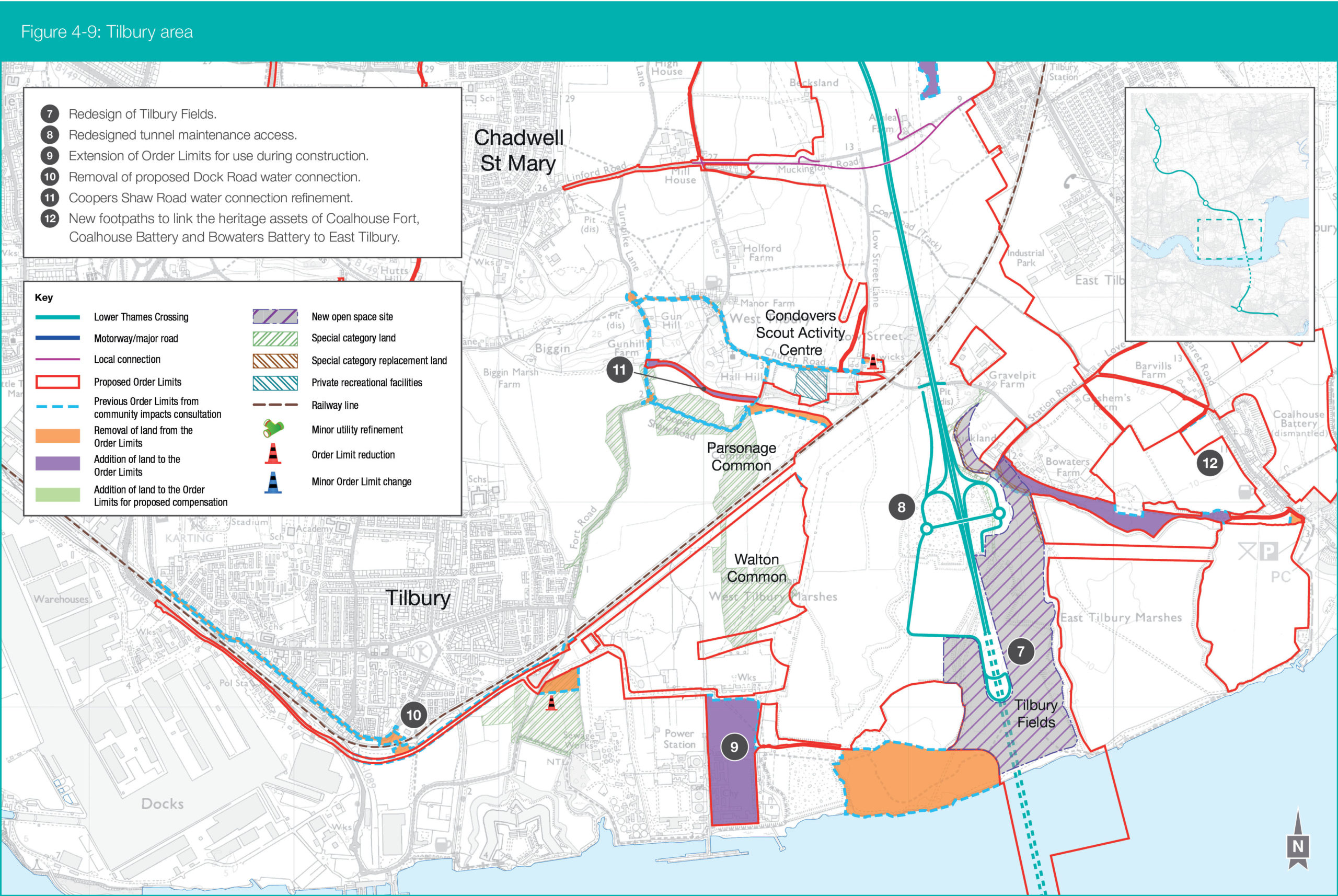
Proposed location of Tilbury Fields
Map reference: 7
Lower Thames Crossing proposals: An area of land previously identified for Tilbury Fields on the western side of the area (that borders the riverfront) has been relocated to the eastern side of the LTC . This is due to the land previously identified being required for the potential future development of Thames Freeport.
Proposed landscaping would provide accessible footpaths to the top of the landform, which connect with the existing local footpath network. New footpaths within Tilbury Fields would ensure the park could be accessed via the Two Forts Way in the south and in the north via footpath FP200.
Alongside other footpath improvements in the Tilbury area, there would be enhanced recreational walks and loops connecting Tilbury Fields to the wider landscape and better access to the riverfront. For details on FP200 at Tilbury Green, see the Special category land page.
The landscape design for Tilbury Fields, along with the existing area of habitat to the west, would improve habitat connectivity. New areas of habitat creation within Tilbury Fields would link established ecological habitats to the west of Tilbury Fields with new habitats further to the east at Mucking Flats and Marshes landfill restoration and the Thameside Nature Reserve.
The revised proposal would also introduce a new link to other new habitats proposed at Linford to the north, improving habitat connectivity in this area.
At the community impacts consultation, we proposed two significant landforms at a maximum height of up to 22.5 metres above ordnance datum level (height of the mean sea level).
In our revised location, we are now proposing several placemaking landforms that will range from 18 to 24 metres in height to the south and east of the northern tunnel entrance. These would provide a visual separation between East Tilbury and the more industrial emerging development that is expected as Thames Freeport seeks to unlock the opportunities in the local area. These landforms would also offer far-reaching views of the Thames Estuary and nearby heritage features, such as Coalhouse Fort, Cliffe Fort and Shornemead Fort.
The largest mound, at the south-east corner of Tilbury Fields, would feature a starshaped area 22 to 24 metres above ordnance datum level that would act as a focal and destination point.
Impact of the change: As a result of repositioning the proposed Tilbury Fields, the following changes in impacts to those set out at the community impacts consultation have been identified:
- Improved access to the riverfront as a result of moving the proposed bridleways and pathways to provide a north-south link.
- Access to more recreational routes in this area than presented at the community impacts consultation. The newly proposed footpaths would link to existing Public Rights of Way and new permissive paths (paths that are privately owned but the owner has allowed the public to access) that are being provided by the project. For details on the recreational routes and Public Rights of Way, see the Improvements for walkers, cyclists and horse riders page.
- There may be a change to the noise impacts for the residential areas towards East and West Tilbury while the landforms are being built. These changes are unlikely to be noticed above other construction activities in this area. In the community impacts consultation, we predicted that the background noise level would be exceeded on occasion at certain locations in East Tilbury (Points 1, 4, 5 and 11 of figure 12.14 of the East Tilbury ward impact summary). The changes we are proposing are predicted to result in impacts that are in line with those reported in the community impacts consultation. The operational impacts are also expected to be in line with those represented in figure 12.20 of the East Tilbury ward impact summary, with impacts ranging from major (greater than a 5dB increase) to negligible (less than a 1dB increase).
- The amount of open mosaic habitat being proposed within Tilbury Fields would marginally increase but the total area will remain at about 45ha. The habitat will, however, be across several areas within Tilbury Fields, rather than in one single area as previously proposed.
- The landscape proposals would remain sympathetic to the historic environment as per the previous design. However, the design reflects the circular nature of Coalhouse Fort and the gun embankments of Tilbury Fort, rather than the more angular geometry of the forts within the wider Thames Estuary. The newly proposed earthworks extend further north than the previous design, and provide an opportunity to screen the views west from Coalhouse Fort of the emerging development of Thames Freeport, which is more industrial in nature. This design responds to the expected development at the Freeport.
North of the tunnel entrance and south of the Tilbury Loop railway line
Map reference: 8
Lower Thames Crossing proposals: We have modified our proposals to include operational access roads so that maintenance and emergency vehicles can access the LTC. This will improve the safety of the new road once it is in operation.
We have introduced a new bridge that would allow National Highways operational vehicles and emergency service vehicles to cross over the new road at this location. As a result, we have been able to remove the access road on the eastern side of the route.
The access road along the western side of the LTC has been re-routed to allow us to reuse the haul road that was previously only required during construction, making better use of this infrastructure. The operational and emergency access to Station Road has been maintained to the west of the route, with minor amendments to connect into the modified access roads.
There would be no access for public traffic on or off the LTC at this location. The operational access could potentially accommodate further development in the future.
Any new road connecting to the LTC at this point would have to follow the relevant planning process at the appropriate time. As a result of the changes to the access roads, two further alterations have been made to the engineering design in this area:
- The flood protection for the tunnel entrance has been changed from flood bunds to concrete retaining walls, which can be built earlier to provide better flood protection during the construction works. On the western side, an earth embankment would blend the wall into the landscape, while on the eastern side, the wall would be integrated into the revised Tilbury Fields landforms.
- The main attenuation pond, to contain and manage storm water, which was to the west of the LTC in this area, has now been relocated within the footprint of the new operational access.
Impact of the change: As a result of the changes to our operational access and environmental mitigation, the following changes in impacts compared with those we presented at the community impacts consultation are predicted:
- The addition of the bridge over the LTC allows us to reduce the number of accesses from Station Road from two to one.
- The new operational access arrangement will give emergency services the flexibility to turn vehicles around in the event of an incident further north or south on LTC . This was not possible with the previous operational layout at this location.
- Aligning the access road on the western side of the LTC with the proposed construction haul road will reduce the overall level of construction works in this area, helping to reduce construction noise and air quality impacts for local residents.
- The new operational access arrangement at Tilbury has been designed, in consultation with key stakeholders, with possible future development in mind, helping to avoid potentially disruptive re-work at a later date. The previous design may have required substantial work in this area. This is a significant benefit with this layout compared with that presented at the community impacts consultation.
- The form of flood protection has been changed from flood bunds to concrete retaining walls. It is predicted that this will have a minor detrimental visual impact for those using the LTC but is unlikely to be noticeable from the west or east of the new road, due to the nearby adjacent landforms screening the LTC.
- Moving the attenuation pond to sit within the footprint of the new operational access.
In addition to the above:
- In the context of Tilbury Fields we expect that there would be minimal impacts on the landscape and views of the built heritage in this area as a result of the new bridge.
- To accommodate the revised design, the land required to secure rights for the utility companies to construct and operate their overhead power line networks has been modified. A small section of the West Tilbury Main River would need to be realigned because of the revised operational access arrangements. This does not change the conclusions of our previous assessments, which confirmed that there would be no significant effects to the water environment in this location.


West of the LTC, on the site of the former Tilbury Power Station
Map reference: 9
Lower Thames Crossing proposals: We are working with the Port of Tilbury to refine our construction activities and support the future plans for Thames Freeport. As part of this work, we have extended our Order Limits to include the former Tilbury Power Station and former coal yard sites so they can be used during construction.
We are also working with the developers of the Thurrock Flexible Generation Plant and Port of Tilbury to coordinate the multiple construction plans and accesses for this area, increasing the sustainability of the combined development plans.
Impact of the change: As this area is next to the Tilbury2 facility and has formerly been the site of a power station, activities here are not likely to lead to new significant environmental effects. This is because of the recent clearance of this industrial site.
The measures we published as part of the community impacts consultation in the draft Code of Construction Practice and the Register of Environmental Actions and Commitments would be applied to control activities on the site.
Dock Road, Hume Avenue and Port of Tilbury
Map reference: 10
Lower Thames Crossing proposals: Two routes were previously proposed at the design refinement consultation to supply water to the northern tunnel entrance compound for the construction and operation of the LTC. One was along Coopers Shaw Road and the other was along Dock Road.
Following discussions with Essex and Suffolk Water, and a further understanding of how the network operates, it has been determined that the water pipeline connection around Coopers Shaw Road (that has also been amended following feedback from the community impacts consultation and is the next detailed change in this chapter) would be sufficient.
As a result, the previously proposed pipeline along Dock Road would no longer be required and the land associated with this proposal has been removed from the Order Limits.
Impact of the change: A change to the water pipe connection means that the pipeline would not be required on a residential road (Dock Road), reducing the impact for local residents.
Traffic management measures associated with the installation of the water pipe connection on Dock Road would no longer be required. These included lane closures and traffic lights on 1.4km of the affected road in 300-metre sections for nine months. This would reduce the impact on this road compared with proposals presented at the community impacts consultation.
Coopers Shaw Road (and fields to the north), and Gun Hill
Map reference: 11
Lower Thames Crossing proposals: Following ongoing discussions with Essex and Suffolk Water, further understanding of how the network operates, and having considered the potential noise impacts for residents on Rectory Road, we have decided that the proposed water pipeline should be located around Coopers Shaw Road. The new pipeline route we are proposing results in a connection point along Gun Hill and avoids impacts on common land.
As a result, the proposed pipelines along Dock Road and Rectory Road are no longer required. The land associated with these proposals along Dock Road, Hume Avenue, the A1089 to Fort Road access road, Rectory Road, Church Lane and part of Station Road have been removed from the Order Limits.
Impact of the change: Changing the route of the pipeline in the way that we propose means that we no longer impact Walton Common and Parsonage common land.
The route of the pipeline has also been moved away from residential properties along Rectory Road, reducing potential construction noise in that location.
Moving the route of the pipeline impacts on a new area of land to the north of Coopers Shaw Road. However, this would be temporary and the land would be reinstated once the pipeline has been installed.
There would be a need to revise the traffic management proposals as a result of this change from those presented at the community impacts consultation:
- There would now be a short term closure of Gun Hill for two weeks, removing the need for the three-way traffic lights at the junction of Gun Hill, Fort Road and Coopers Shaw Road.
- There would now be single lane traffic and traffic lights along a 50-metre stretch of Coopers Shaw Road for one month, reduced from single lane traffic along a 650-metre stretch.
- Three-way traffic lights would be removed at the junction of Gun Hill, Fort Road and Coopers Shaw Road.
- Rectory Road/Church Road/Station Road would now be reduced to a single lane for a 150-metre section of Station Road, south of the Tilbury Loop railway line for two months, reduced from the lane closures and traffic lights in 300-metre sections across a 1.5km section for nine months.


North of Muckingford Road, west of Linford
Map reference: 13
Lower Thames Crossing proposals: Following the 2021 community impacts consultation and ongoing engagement with UK Power Networks, we are now proposing a new way of delivering the diversion of electricity lines in this location. This is because more detailed investigations have shown that what we previously proposed would be incompatible with the existing infrastructure in this location.
We plan to retain part of an existing overhead powerline that we previously proposed would be underground. This would be achieved by constructing a temporary pylon, east of the existing one, between Muckingford Road and the allotments. The overhead powerlines would be realigned via the temporary pylon while the existing one is removed and a new terminal pylon is built in its place. The temporary overhead powerlines would then be relocated on to the new pylon heading north and on reaching the new terminal pylon, would be installed underground, joining the previously proposed route heading south.
The temporary pylon and overhead powerlines would then be removed.
To achieve this, the Order Limits need to be increased to the south-west of Linford. Some of the land previously proposed for temporary use only would now need to be changed to temporary use with the permanent acquisition of rights.
Our revised proposal would ensure that the required changes to the electricity network in this location can be delivered, while being sensitive to the local environment and community.
Impact of the change: The residents of Linford would see a new type of pylon replacing an existing one and would continue to see approximately 300 metres of existing overhead powerlines that were previously proposed to be laid underground. There would not therefore be a significant change in visual effects, compared with the existing setting.
Some vegetation would need to be removed to complete these works.
Brentwood Road, south of the Orsett Cock junction
Map reference: 14
Lower Thames Crossing proposals: Following the 2021 community impacts consultation and ongoing engagement with Essex and Suffolk Water (ESW), we have developed our knowledge of how the water network would operate once diversions to the rest of the network have been carried out.
We are proposing to divert a water pipeline along the A1013. The diverted asset severs a link with the existing water pipeline located further east and we have identified that this would have left residents without a water supply. The proposal that we are now presenting would reconnect residents by providing a new water pipe from the existing supply.
To accommodate this proposal, there will need to be an extension of the Order Limits to enable ESW to construct the additional connection. There would also be a need to acquire permanent rights for ESW to operate and maintain this connection.
Impact of the change: This change ensures that we can maintain a water supply to residents’ properties.
Installation of an additional section of water pipe would require excavations closer to residents east of Brentwood Road. This would result in a temporary increase in construction activity, including noise, for these residents. However, the works would only take place for a very short period of time. All of these works would be completed during the day and access to properties would be maintained.
It is proposed that the works would be delivered using the traffic management measures that were published during the community impacts consultation. Traffic lights and lane closures are proposed in 300-metre sections to enable the works to take place. The proposed pipeline connection is expected to take a few weeks to complete.

Various locations around the A13/A1089 junction
Map reference: 15
Lower Thames Crossing proposals: We are proposing six landscaping features where the project would join the A13, as shown in Figure 4-16. This shows the extents and describes the levels of the proposed features.
The additional landscaping would be located within the Order Limits, which we presented in the 2021 community impacts consultation, and relates to land previously identified for woodland and other planting alongside the new road. No further land would therefore be required to accommodate these changes. The details of the planting mix to be used within these new landscaped areas will be set out in the Outline Landscape and Ecology Management Plan as part of our DCO submission.
Material for the construction of the landscape features would be re-used from elsewhere within the project, reducing the need to use local waste management facilities.
Impact of the change: The placing of clean excavated material from construction activities in these areas would provide noise, landscape and visual benefits for some nearby residents and maximise these benefits.
This is particularly apparent at Area F. In this location, the landscaping would provide partial screening to the A13 junction. This means that the landscaping feature would make the road less visible to residents of The Whitecroft care home.


A link road south of the A13, between the Orsett Cock junction and the A1089
Map reference: 16
Lower Thames Crossing proposals: Following feedback from stakeholders and further comments from consultees on the traffic modelling presented at the community impacts consultation, which raised concerns about the re-routing of traffic on to local roads, we have revised the link road. This addresses these concerns, reducing the traffic on Brentwood Road and the A1013 Stanford Road in comparison to our traffic forecasts with the project that were presented in summer 2021.
The A1089 southbound is currently accessed from a link road off the A13 westbound, which is to the west of the Orsett Cock junction.
As part of our design, we proposed moving it so that traffic using the link road would leave the A13 earlier, and before westbound traffic from the Orsett Cock junction would join the A13.
We now propose a change to the connection from the A13 westbound to the A1089 southbound that would be accessed directly from the Orsett Cock junction. Traffic would be able to access the A1089 southbound from the A13 and Orsett Cock junction without the need to use local roads. Westbound traffic on the A13 to the east of the Orsett Cock junction would need to leave the A13 at the Orsett Cock junction to access the new link road to the A1089 southbound.
Impact of the change: The modified link road from the Orsett Cock junction would improve connectivity between the LTC and the Port of Tilbury (including the planned Thames Freeport), and central Grays as shown in Figures 4-19 and 4-20. This would reduce the impact of the LTC on traffic on a number of local roads in the area. Some roads, however, would see an increase in traffic.
The scale and extent of the predicted changes in traffic flows differs in each peak period as shown in Figures 4-21 to 4-26 and as described below.
As a result of the introduction of the new link road, there is expected to be a reduction in traffic flows on Brentwood Road, the A1013 Stanford Road, and west of the proposed A13/A1089 LTC junction on the M25 and A13.
In addition, there is predicted to be an increase in traffic flows on Rectory Road/Conways Road, between the Orsett Cock junction and the A1089, Marshfoot Road, on the A1089 southbound, and southbound traffic on the new road between the M25 and the A13.
Figures 4-27 to 4-32 present the predicted change in traffic as a result of the project, providing an update from the information given in the community impacts consultation.
Air quality and noise are impacted by traffic flows. Therefore, the changes in traffic flows around the A13/A1089 junction as a result of this additional link means there would be localised changes (including increases and decreases) in air quality and traffic noise levels along roads, compared with those presented at the community impacts consultation. These changes are described below.
The air quality and noise impact of the new link road from the Orsett Cock junction will be fully assessed and presented in the Environmental Statement as part of our DCO submission.
Changes to connections at the A13/A1089 junction
Figures 4-19 and 4-20 show the connections at the A13/A1089 junction between the new road and the A1089 and the A13 westbound and the A1089. Figure 4-19 shows these connections in line with the design presented at the community impacts consultation, while Figure 4-20 shows the connections as a result of the new link road.


Predicted changes in traffic since the community impacts consultation as a result of the new link road
Figures 4-21 to 4-26 show the predicted change in traffic as a result of the new link road, (compared with the 2021 community impacts consultation).
Figures 4-21 to 4-23 show the predicted changes in traffic flow and Figures 4-24 to 4-26 show predicted changes in traffic as a percentage.


A summary below describes the predicted changes in traffic as a result of the proposed new link road from the Orsett Cock junction to the A1089.
The ‘bands’ in which the traffic flow changes are shown in Figures 4-21 to 4-24 differ to those presented at the community impacts consultation and those in Figures 4-27 to 4-29, to clearly show the change resulting from the new link road.
The changes are modelled in the morning peak (7am to 8am), inter peak (an average hour between 9am and 3pm), and the evening peak (5pm to 6pm) and are measured in Passenger Car Units (PCUs) per hour, where one PCU is equal to a car and 2.5 PCUs is equivalent to an HGV.
Traffic on the Lower Thames Crossing heading to the A1089. Leave the Lower Thames Crossing northbound and follow the road, looping back to cross over the Lower Thames Crossing, or leave the Lower Thames Crossing southbound and follow the road, travelling under Stifford Clays Road. These connections merge and head to the Orsett Cock junction. From there, take either the A128 Brentwood Road or A1013 Stanford Road and use the local road network to reach the A1089.
Traffic on the A13 westbound heading to the A1089. Leave the A13 westbound and follow the road, travelling over the connection between the A13 westbound and Lower Thames Crossing southbound. Continue on the road, passing over the realigned Baker Street and the Lower Thames Crossing, and join the A1089 southbound.
Traffic on the Lower Thames Crossing heading to the A1089. Leave the Lower Thames Crossing northbound and follow the road, looping back to cross over the Lower Thames Crossing, or leave the Lower Thames Crossing southbound and follow the road, travelling under Stifford Clays Road. These connections merge and head to the Orsett Cock junction. At the junction take the sixth exit and follow the road, travelling under Rectory Road and over the connection between the A13 westbound and Lower Thames Crossing southbound. Continue on the road, passing over the realigned Baker Street and the Lower Thames Crossing, and join the A1089 southbound.
Traffic on the A13 westbound heading to the A1089. Leave the A13 westbound at the Orsett Cock junction, and take the fourth exit and follow the road, travelling under Rectory Road and over the connection between the A13 westbound and Lower Thames Crossing southbound. Continue on the road, passing over the realigned Baker Street and the Lower Thames Crossing, and join the A1089 southbound.
Description of the predicted changes in traffic from those we consulted on in 2021, as a result of the new Orsett Cock junction to A1089 link road
Lower Thames Crossing: Southbound traffic on the LTC between the M25 and the A13 is predicted to increase by between 101 and 250 PCUs in the morning and evening peaks, and by up to 50 PCUs in the inter peak. This would be an increase of up to 10% in all modelled time periods.
New link road: The newly proposed link road between the Orsett Cock junction and the A1089 is predicted to carry between 501 and 825 PCUs in all modelled time periods.
A13: West of the proposed A13 junction with the LTC, eastbound traffic levels on the A13 are predicted to decrease by up to 249 PCUs in the morning and evening peaks, and between 50 and 99 PCUs in the inter peak.
This would be a decrease of up to 10% in all modelled time periods.
A1013 Stanford Road: South of the A13, westbound traffic levels are predicted to fall on the A1013 Stanford Road west of the Orsett Cock junction by between 150 and 249 PCUs in all modelled time periods. In the morning peak, this would be a decrease of between 20% and 40% between Rectory Road and the Daneholes roundabout, and more than 40% between Rectory Road and the Orsett Cock junction.
In the inter and evening peaks this would be a decrease of between 20% and 40%.
Marshfoot Road: In the morning peak, eastbound traffic on Marshfoot Road east of the A1089 is predicted to increase by between 101 and 250 PCUs. This would be a rise of between 20% and 40%.
A1089: On the A1089, southbound traffic between the A13 and the junction with Marshfoot Road is predicted to rise by between 251 and 500 PCUs in the morning peak, 101 and 250 PCUs in the inter peak and 251 and 500 PCUs in the evening peak. This would be an increase of between 10% and 20% in all modelled time periods.
Southbound traffic on the A1089 between the junction with Marshfoot Road and the Asda roundabout is also predicted to increase by between 51 and 100 PCUs in the inter and evening peaks. This would be a rise of up to 10%.
Brentwood Road: Brentwood Road runs north-south through the Orsett Cock junction. It is predicted to see a decrease in traffic southbound of between 50 and 99 PCUs in the morning and inter peak periods between its junctions with Conways Road and Linford Road. North of the A13, this would be a drop of up to 10% in the morning peak and between 10% and 20% in the inter peak. South of the A13, this would be a decrease of between 20% and 40%.
In the evening peak, it is predicted that north of the A13, there would be a decrease of between 50 and 99 PCUs as far as the junction with Conways Road. South of the A13, there would be a predicted drop southbound of between 50 and 99 PCUs as far as the junction with Marshfoot Road. North of the A13, there would be a decrease of up to 10%, while south of the A13, there would be a drop of between 10% and 20%.
Conways Road and Rectory Road: North of the A13, traffic on Conways Road/Rectory Road is predicted to increase by between 51 and 100 PCUs westbound/southbound in the morning peak and northbound/eastbound in the evening peak.
During the inter peak, westbound/southbound traffic on Conways Road/Rectory Road is predicted to increase by between 101 and 250 PCUs to the junction with the B188 High Road. A rise of between 51 and 100 PCUs is predicted on Rectory Road between the junction with the B188 High Road and the A1013. This would mean an increase of more than 40% in all modelled time periods.
Predicted changes in traffic as a result of the Lower Thames Crossing
While Figures 4-21 to 4-26 present the predicted change in traffic as a result of the new link road between the Orsett Cock junction and the A1089 only, Figures 4-27 to 4-32 show the forecast change in traffic as a result of the project overall.
These figures provide an updated picture of the predicted impact of the project on the road network from that shown in the Operations update at the community impacts consultation.
Figures 4-27 to 4-29 show the predicted change in traffic volumes, and Figures 4-30 to 4-32 show the predicted change in traffic as a percentage.
The area shown is where our predictions have changed since the community impacts consultation. Elsewhere, our predicted impacts on the road network remain the same.
The changes are modelled in the morning peak (7am to 8am), inter peak (an average hour between 9am and 3pm), and the evening peak (5pm to 6pm) and are measured in Passenger Car Units (PCUs) per hour, where one PCU is equal to a car and 2.5 PCUs is equivalent to an HGV.


Air quality and noise impacts predicted as a result of the newly proposed A13/A1089 link road
Air quality and noise are directly affected by the predicted changes in traffic flows that result from the newly proposed A13/A1089 link road.
At the community impacts consultation, we presented noise and air quality impacts for wards directly affected by the scheme. These impacts were based on the predicted traffic flows from the community impacts consultation version of the project’s transport model.
To understand if there would be changes to air quality or noise impacts as a result of the newly proposed A13/A1089 link presented at this consultation, we compared the predicted traffic flows presented at the community impacts consultation with our latest traffic modelling (which includes the newly proposed link road). See our findings below.
Where increases in predicted traffic flows have been identified, this may lead to greater changes in air quality and road traffic noise than those presented at the community impacts consultation. Where reductions in predicted traffic flows have been identified, this may lead to an improvement in air quality and road traffic noise compared with those presented at the community impacts consultation. However, when looking at the overall impact of the project, it is expected that the impacts will be in line with those presented previously.
Predicted changes in air quality and noise impacts from those presented at the community impacts consultation, as a result of the new Orsett Cock junction to A1089 link road
Rectory Road, Conways Road and High Road (eastern end): As a result of the new proposal, it is expected that Rectory Road, Conways Road and High Road (the eastern end) may see an increase in predicted traffic flows.
However, the predicted changes to road traffic noise along Rectory Road, Conways Road and High Road are similar to those presented at the community impacts consultation, with negligible (less than 1dB(A)) to minor (1 to 2.9dB(A)) reductions in noise compared with if the LTC was not built (as shown in Figure 16.20 of the Ward impact summaries – North of the river part 1).
The change in predicted traffic flows along Rectory Road, Conways Road and High Road is also predicted to result in similar air quality impacts to those presented at the community impacts consultation. Changes in air quality in this area presented at the community impacts consultation were predicted to be negligible, compared with if the LTC was not built (as shown in Figure 16.21 of the Ward impact summaries – North of the river part 1).
Brentwood Road: As a result of the new proposal, a reduction in traffic flows is predicted along Brentwood Road north and south of the Orsett Cock junction.
However, the change in predicted traffic flows along Brentwood Road north and south of the Orsett Cock junction is not predicted to result in a change to noise impacts which we presented at the community impacts consultation.
Changes in road traffic noise along Brentwood Road north of the Orsett Cock junction are expected to remain similar to those presented at the community impacts consultation, with minor (1 to 2.9dB(A)) reductions predicted, compared with if the LTC was not built (as shown in Figure 16.20 of the Ward impact summaries – North of the river part 1).
With regard to Brentwood Road south of the Orsett Cock junction, noise impacts are again expected to remain similar to those presented at the community impacts consultation, with negligible impacts (less than 1dB(A)) increasing to major (greater than 5dB(A)) increases in noise where Brentwood Road approaches and crosses the new road (as shown in Figure 15.19 of the Ward impact summaries – North of the river part 1).
The change in predicted traffic flows along Brentwood Road north and south of the Orsett Cock junction are predicted to result in similar air quality impacts to those presented at the community impacts consultation. Changes in air quality presented at the community impacts consultation were predicted to range from minor improvements along Brentwood Road north of the Orsett Cock junction to a minor worsening along Brentwood Road south of the Orsett Cock junction, compared with if the LTC was not built (as shown in Figures 15.20 and 16.21 of the Ward impact summaries – North of the river part 1).
Roads west and east of the A13/A1089 junction: As a result of the new proposal, traffic flows on the A13 to the west of the A13/A1089 junction and eastbound traffic flows east of the Orsett Cock junction are predicted to see a reduction, although these changes are unlikely to be significant. Predicted increases in forecast traffic flows may occur at the LTC southbound off-slip to the east of the A13/A1089 junction, along the new link road between the Orsett Cock junction and the A1089, and at the westbound A13 off-slip on to the Orsett Cock junction.
However, the change in predicted traffic flows along the westbound A13 off-slip is predicted to result in similar noise impacts to those presented at the community impacts consultation, which predicted a major (greater than 5dB(A)) reduction in road traffic noise compared with if the LTC was not built (as shown in Figure 16.20 of the Ward impact summaries – North of the river part 1).
The change in predicted traffic flows along the westbound A13 off-slip and eastbound traffic flows east of the Orsett Cock junction are predicted to result in similar air quality impacts to those reported at the community impacts consultation. Changes in air quality in this area presented at the community impacts consultation were predicted to range from negligible to a minor worsening in air quality, compared with if the LTC was not built (as shown in Figure 16.21 of the Ward impact summaries – North of the river part 1).
The new proposal is predicted to see an increase in traffic flows, which is likely to increase noise impacts close to the southbound off-slip of the Lower Thames, to the east of the A13/A1089 junction. At the community impacts consultation, we presented the noise impacts of the proposed southbound off-slip for the LTC, to the east of the A13/A1089 junction. This showed moderate (3 to 4.9dB(A)) to major (greater than 5dB(A)) reductions in noise levels, as a result of the LTC’s proposed low-noise road surfacing and junction earthworks (as shown in Figure 16.20 of the Ward impact summaries – North of the river part 1). The link road proposed at this consultation is likely to increase road traffic noise as a result of predicted increased traffic flows.
A1013 Stanford Road: As a result of the new proposal, a reduction in traffic flows is predicted close to the A1013 Stanford Road.
However, the change in predicted traffic flows along the A1013 Stanford Road is predicted to result in similar noise impacts with those presented at the community impacts consultation. Changes in road traffic noise along this section of A1013 Stanford Road are expected to remain similar to those presented at the community impacts consultation, with minor (1 to 2.9dB(A)) reductions predicted, compared with if the LTC was not built (as shown in Figure 16.20 of the Ward impact summaries – North of the river part 1).
The change in predicted traffic flows along the A1013 Stanford Road is predicted to result in similar air quality impacts to those presented at the community impacts consultation. Changes in air quality in this area presented at the community impacts consultation were predicted to result in a minor worsening in air quality, compared with if the LTC was not built (as shown in Figure 16.21 of the Ward impact summaries – North of the river part 1).
A1089 southbound: As a result of the new proposal, the A1089 southbound between the A1013 and the Marshfoot Road junction is predicted to see an increase in traffic flows.
The change in predicted traffic flows along the A1089 southbound is predicted to result in noise impacts similar to those presented at the community impacts consultation. Changes in road traffic noise along this section of the A1089 southbound are expected to remain similar to those presented at the community impacts consultation with minor (1 to 2.9dB(A)) reductions predicted, compared with if the LTC was not built (as shown in Figures 15.19 and 17.18 of the Ward impact summaries – North of the river part 1).
The change in predicted traffic flows along the A1089 southbound is predicted to result in air quality impacts similar to those presented at the community impacts consultation. Changes in air quality in this area presented at the community impacts consultation were predicted to be negligible, compared with if the LTC was not built (as shown in Figures 15.20 and 17.19 of the Ward impact summaries – North of the river part 1).
Marshfoot Road: As a result of the new proposal, reductions in traffic flows are predicted close to Marshfoot Road.
The change in predicted traffic flows along Marshfoot Road is predicted to result in similar noise impacts to those presented at the community impacts consultation. Changes in road traffic noise along this section of Marshfoot Road are expected to remain similar to the community impacts consultation with negligible (less than 1dB(A)) changes predicted, compared with if the LTC was not built (as shown in Figures 14.15, 15.19 and 17.18 of the Ward impact summaries – North of the river part 1).
The change in predicted traffic flows along Marshfoot Road is predicted to result in similar air quality impacts to those presented at the community impacts consultation. Changes in air quality in this area presented at community impacts consultation were predicted to be negligible, compared with if the LTC was not built (as shown Figures 14.16, 15.20 and 17.19 of the Ward impact summaries – North of the river part 1).
Environmental statement
The air quality and noise impacts of the new link road between the Orsett Cock junction and the A1089 will be fully assessed and presented in the Environmental Statement included as part of our DCO submission.


North of the A13, from Baker Street to near the A128 Brentwood Road and east of the Orsett Cock junction, south of the A13
Map reference: 17
Lower Thames Crossing proposals: We propose to refine the route of a gas pipeline diversion in this location, to avoid a scheduled monument west of Orsett. The Order Limits have been modified as a result of this change and the pipeline can now pass through a gap in the existing vegetation, removing a risk to a veteran tree.
There would be a minor extension of the Order Limits to allow for modifications to be completed to the existing network east of Orsett Cock junction.
The new gas pipeline alignment is shown in Figure 4-36.
We are carrying out assessments to understand whether the change we are proposing to the route of this pipeline affects the NSIP status of the diversion. Our DCO application will set out all of the utilities NSIPs for which consent is being sought.
Impact of the change:
Realigning this gas pipeline diversion and amending the working area means we can avoid a significant impact on a scheduled monument. We can also retain a veteran tree that was previously at risk of removal from the gas pipeline diversion.
To the west of Mill Lane the working area would move east by 30 metres, bringing it within 50 metres of the nearest residential property. The gas pipeline would move east by seven metres.
Construction noise levels here are not predicted to exceed the existing background noise levels. The existing vegetation would screen the visual impact of moving the works closer to these residential properties.
There would be a closure of the A128 southern access to a layby for up to two months. Access to the layby from the north would not be affected.


Section of the route that passes under North Road crossing (near The Wilderness)
Map reference: 20
Lower Thames Crossing proposals: At our previous consultation the 2.2km section of road at this location was proposed to be in a cutting up to 6.5 metres below ground level.
As a result of further design refinement, we are proposing to raise the road alignment while maintaining the required headroom clearance beneath existing structures.
The depth of the cutting would be reduced by one metre to 5.5 metres below ground level for around 2.4km.
Impact of the change: By raising the road in this location the amount of excavated material being removed by road would be considerably reduced.
The change in road level would be marginal. There would be no significant change in noise and visual impacts during construction and operation for nearby communities.

M25/LTC junction (North Ockendon)
Map reference: 21
Lower Thames Crossing proposals: We are proposing additional landscaping up to six metres from the existing ground level with planting around the M25/LTC junction.
We are also proposing two other landscaping features (areas A and B) around the junction between the LTC and the M25.
Figure 4-41 shows the extent and describes the levels of the three features proposed. The additional landscaping would be within the Order Limits presented in the 2021 community impacts consultation and would relate to land identified for woodland and other planting along the new road. No further land would be required to accommodate this change. The detailed planting mix to be used within these new landscaped areas will be included in the Outline Landscaping and Ecological Management Plan as part of our DCO submission.
Material for the construction of the landscape features would be re-used from elsewhere within the project, reducing the need to use local waste management facilities.
Impact of the change: The placing of clean excavated material from construction activities in this area would provide noise, landscape and visual benefits for some nearby residents and maximise these benefits.
This is particularly apparent at Area C, where the most significant landscaping changes are proposed. In this location, the LTC would be constructed below ground level, so the road would be less visible to local residents. It would also reduce the level of noise for surrounding communities.


LTC/M25 junction (North Ockendon)
Map reference: 22
Lower Thames Crossing proposals: At our previous consultation, the 1.5km section of road at this location was proposed to be in a cutting up to 11.3 metres below ground level.
As a result of further design refinement, we are proposing to raise the height of the road alignment while maintaining the required headroom clearance beneath existing structures.
The depth of the cutting at the LTC/M25 junction would be reduced by 1.5 metres to 9.8 metres below ground level for around 1.5km.
Impact of the change: By raising the road alignment in this location the amount of excavated material removed by road would be considerably reduced.
The change in height would be marginal and there would be no significant change in noise and visual impacts here during construction and operation.

To the west of Clay Tye Road and within Thames Chase Community Forest, Upminster
Map reference: 23
Lower Thames Crossing proposals: Following site investigations by the utility company (UK Power Networks) and feedback from landowners, we have refined our proposal to divert electricity cables in this location, as proposed at the supplementary consultation (see Figure 4-46). Overhead powerlines would now be diverted along two new taller pylons north of their current position either side of the M25. We would also divert another electricity cable through the proposed Thames Chase footbridge, removing the need for trenchless installation of the cables under the M25, as previously proposed at the supplementary consultation (see Figure 4-46).
This change would use more of the existing electricity infrastructure to deliver the proposal and removes the requirement for a substation to be built along Clay Tye Road. It also reduces the extent of works previously proposed to the east and west of the M25, resulting in some changes to the Order Limits in this location.
Impact of the change: The new proposal reduces the amount of land and time required for construction of the utility diversion in the Thames Chase Community Forest and neighbouring farmland as cables would no longer need to be installed under the M25.
While there would be an increased visual impact associated with the overhead powerlines from the plans presented at the community impacts consultation, our new proposal only results in a minor change to the existing overhead powerlines in this location.
Our revised proposal would require the removal of some vegetation in Thames Chase Community Woodland, which would be replanted.


South of the Shoeburyness railway line (between Upminster and Laindon), west of the B186 Warley Street
Map reference: 24
Lower Thames Crossing proposals: As first proposed at supplementary consultation in March 2020, we would need to divert an existing electricity cable in this location. The diversion would still be required but we are proposing a refinement that would reduce its impact. The change we are now proposing, which has been discussed with UK Power Networks, involves moving the construction area 30 metres to the east.
This proposal would result in a reduction in the Order Limits to the north of Tyas Stud Farm as the land is no longer needed.
Permanent rights of access would be required from Warley Street for the operation and maintenance of the network by UK Power Networks. There would also be a minor increase in the Order Limits to the east of the cable diversion to accommodate the construction of these works.
Impact of the change: This proposal means the works to divert this electricity cable can be moved further away from residential properties, reducing construction impacts for residents.
Access for construction, operation and maintenance of the cable is now proposed to be from the east through neighbouring agricultural fields and past some residential properties. It is anticipated that any future access requirements would be infrequent.
Traffic lights or similar are now proposed on the B186 (Warley Street) for two weeks to build the access.